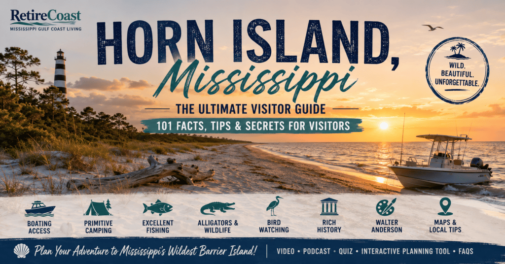
Horn Island, Mississippi, is one of the Gulf Coast’s most beautiful, historic, and misunderstood barrier islands—a remote wilderness of white-sand beaches, freshwater ponds, abundant wildlife, and remarkable stories.
Try our free tool:
Which Barrier Island is Right For You at the end of this article.
What This Article Helps You Discover
Whether you’re planning a day trip, researching Mississippi’s barrier islands, or simply wondering about the alligators that inhabit Horn Island, this guide will help you:
- Learn where Horn Island is located and why it is one of Mississippi’s most important barrier islands.
- Discover why American alligators live on Horn Island and where they are most commonly found.
- Understand how alligators reach the island despite living primarily in freshwater habitats.
- Explore Horn Island’s unique freshwater ponds, marshes, beaches, dunes, and maritime forests.
- Learn how the island helps protect Mississippi’s mainland from hurricanes and storm surge.
- Discover the best areas for boating, fishing, kayaking, camping, hiking, birdwatching, shelling, and photography.
- Explore the rich history of Horn Island, from early explorers to famed artist Walter Anderson.
- Learn about the island’s diverse wildlife, including dolphins, sea turtles, migratory birds, and other native species.
- Find answers to the questions visitors most often ask before making the trip.
- Discover practical safety tips for enjoying one of the Gulf Coast’s last truly wild places.
Why This Matters
Whenever Horn Island appears in the news, one question almost always rises to the top of Google searches:
“Are there alligators on Horn Island?”
The short answer is yes.
American alligators have lived on Horn Island for generations, thriving in the island’s freshwater ponds and interior wetlands.
Yet many people are surprised to learn that one of Mississippi’s most beautiful barrier islands supports a healthy alligator population while remaining a favorite destination for boaters, campers, anglers, photographers, and nature enthusiasts.
The reality is that Horn Island is far more than a place where alligators live. It is one of the Gulf Coast’s last undeveloped wilderness islands—a place where shifting sand dunes, pristine beaches, freshwater ponds, maritime forests, and tidal marshes create an ecosystem unlike anywhere else in Mississippi.
Every year, thousands of visitors experience its quiet beauty while rarely encountering an alligator because the reptiles naturally avoid the busy beach areas where people spend most of their time.
Horn Island also serves a much larger purpose. Along with Mississippi’s other barrier islands, it acts as a natural shield that absorbs wave energy, reduces storm surge, protects the Mississippi Sound, and provides essential habitat for hundreds of species of birds, fish, reptiles, and marine life.
Without these islands, Mississippi’s coastline would be far more vulnerable to hurricanes and coastal erosion.
In this guide, we’ll explore everything that makes Horn Island extraordinary—from its fascinating wildlife and rich history to its recreational opportunities, changing geography, and important role in protecting the Mississippi Gulf Coast.
Whether your interest is alligators, fishing, camping, kayaking, or simply discovering one of America’s most remarkable barrier islands, you’ll find the answers here.

Horn Island is more than a beautiful stretch of sand. It is a protected wilderness where visitors can experience undeveloped beaches, freshwater ponds, maritime forests, abundant wildlife, exceptional fishing, and centuries of Gulf Coast history—all within boating distance of the Mississippi mainland.
Unlike Ship Island, Horn Island has no scheduled passenger ferry. Visitors arrive by private boat, charter boat, water taxi, or kayak, helping the island retain its remote and uncrowded character.
There are no stores, restaurants, paved roads, hotels, or utility services. Visitors must bring their own water, food, shade, safety equipment, and everything else needed for the day or an overnight stay.
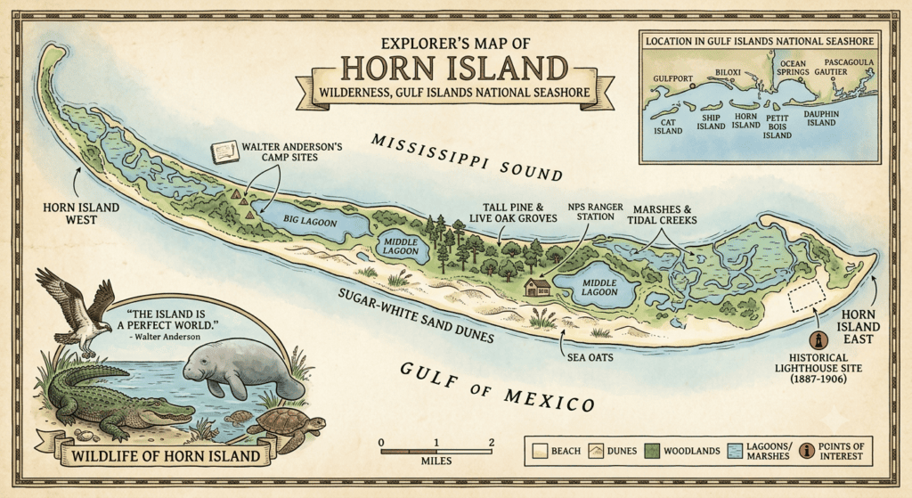
The north shore faces the calmer Mississippi Sound and is commonly used for landing boats. The south shore faces the open Gulf of Mexico, where visitors find wider beaches, surf, and rolling waves.
Rainwater collects in natural depressions behind the dunes, creating freshwater and brackish ponds. These ponds support frogs, turtles, birds, insects, plants, and occasionally American alligators.
Horn Island supports an extraordinary mixture of coastal and inland wildlife, including alligators, sea turtles, raccoons, snakes, dolphins, shorebirds, migratory birds, and numerous marine species.
Anglers fish the beaches, grass beds, channels, passes, and nearby reefs for speckled trout, redfish, flounder, Spanish mackerel, sheepshead, sharks, and other Gulf Coast species.
Visitors may experience a night beneath the stars with the Gulf nearby and few signs of civilization. Camping is primitive, and National Park Service rules protect the dunes, vegetation, nesting birds, and other sensitive areas.
Artist Walter Inglis Anderson repeatedly traveled to Horn Island, often rowing from Ocean Springs and camping alone. Its wildlife, storms, plants, and changing light inspired some of his most celebrated work.
Horn Island has connections to Indigenous travel, European exploration, cattle grazing, lighthouse operations, military activity, historic hunting, hurricanes, and the development of Gulf Islands National Seashore.
More than 280 bird species have been observed across the Mississippi barrier-island region. Horn Island provides feeding, nesting, and resting habitat for resident birds and seasonal migrants.

Watch this short overview for the highlights of Horn Island’s beaches, boating, wildlife, camping, history, and natural beauty.
This short video introduces the most important parts of our complete Horn Island Mississippi guide. It is designed for visitors who want a quick overview before exploring the longer article, detailed maps, photographs, wildlife information, safety guidance, history, quizzes, and frequently asked questions available on RetireCoast.
- How visitors reach Horn Island by boat
- Beaches, dunes, forests, and freshwater ponds
- Camping and visitor preparation
- Wildlife and alligator awareness
- Walter Anderson’s connection to the island
- History, hurricanes, and conservation
Listen to this audio companion to our complete Horn Island guide and discover the island’s beaches, wildlife, history, boating access, camping opportunities, and Walter Anderson legacy.
Horn Island is one of the most remote and unspoiled destinations on the Mississippi Gulf Coast. In this episode, William Anderson shares practical visitor information, local knowledge, historical context, and important safety considerations for anyone interested in this extraordinary barrier island.
- How to reach Horn Island by boat
- Beaches, dunes, forests, and freshwater ponds
- Camping rules and visitor preparation
- Wildlife and alligator safety
- Walter Anderson’s connection to the island
- Hurricanes, history, legends, and conservation
- Try our free tool:
- Which Barrier Island is Right For You at the end of this article.
- What This Article Helps You Discover
- Why This Matters
- Horn Island by the Numbers—Geography, Ponds and Maritime Forests
- A Long, Narrow and Constantly Changing Island
- Horn Island’s Freshwater Ponds
- The Maritime Pine-Oak Woodlands
- Why the Trees Matter
- A Wilderness, Not a Developed Beach
- How Geography Creates Alligator Habitat
- A Landscape That Never Stands Still
- Life on Horn Island — One of the Gulf Coast’s Richest Wildlife Sanctuaries
- Reptiles and Amphibians
- Birds: A World-Class Birding Destination
- Ospreys and Other Raptors
- Shorebirds and Beach Nesters
- Pelicans, Herons and Wading Birds
- Migratory Songbirds
- Mammals
- Marine Mammals
- Marine Life Beneath the Surface
- Crabs and Other Invertebrates
- A Living Wilderness
- What People Often Ask About Horn Island Alligators: The Basics
- Are there really alligators on Horn Island?
- Why are there alligators on a barrier island?
- How do alligators get to Horn Island?
- Are alligators permanent residents of Horn Island?
- Are Horn Island alligators dangerous?
- How Far Is Horn Island from the Mainland?
- How Long Does the Trip Take?
- A Personal Observation
- Walter Anderson: The Artist Who Made Horn Island Mississippi Famous
- Who Was Walter Anderson?
- Why Horn Island Mississippi?
- The Twelve-Mile Journey
- Living on Horn Island Mississippi
- Horn Island Mississippi Became a Living Laboratory
- The Horn Island Logs
- Walter Anderson’s Horn Island Mississippi Today
- Visit the Walter Anderson Museum of Art
- Walter Anderson’s Lasting Legacy
- Camping on Horn Island: A True Wilderness Experience
- What Makes Camping on Horn Island Special?
- Camping Permits
- Where Can You Camp?
- Campfires
- Leave No Trace
- Other Important Rules
- What Should You Bring?
- Author’s Perspective
- A Brief History of Horn Island
- Before European Exploration (Before 1699)
- 1699: How Horn Island Got Its Name
- Early French Settlement
- Changing Flags Over Horn Island
- The Waters Family
- Horn Island During the Civil War
- The Horn Island Lighthouse
- World War II
- Walter Anderson’s Island
- Becoming a Protected Wilderness
- Wildlife Conservation
- Deepwater Horizon Oil Spill
- Horn Island Today
- Horn Island and the American Revolution
- How Deep Is the Water Around Horn Island?
- The North Side: Shallow Water in Mississippi Sound
- The South Side: Gulf Waves and a Faster Drop-Off
- Dog Keys Pass at the Western End
- Horn Island Pass and the Pascagoula Ship Channel
- Why Small Boats Must Avoid the Shipping Lane
- Why the North and South Sides Feel So Different
- Author’s Boating Observation
- What People Often Ask About the Freshwater Ponds
- How deep are the freshwater ponds?
- Are the ponds connected to the Gulf of Mexico?
- Can you swim in the ponds?
- Why don’t the ponds dry up?
- Why are there so many ponds on Horn Island?
- How Did Alligators Get to Horn Island?
- Alligators Are Strong Swimmers
- The Pascagoula River Connection
- Heavy Rain Can Create a Fresher Mississippi Sound
- Floods and Tropical Storms May Move Alligators
- Do Alligators Intentionally Swim to Horn Island?
- Why Horn Island Can Support Them
- Are Some Horn Island Alligators Born There?
- The Pascagoula Delta: Mississippi’s Alligator Stronghold
- Does the Pascagoula Basin Produce Giant Alligators?
- Are Pascagoula Alligators More Dangerous?
- A Better Comparison
- The Most Likely Journey to Horn Island
- What This Means for Visitors
- Can You Hunt Alligators on Horn Island?
- What Do Horn Island Alligators Do During Hurricanes?
- They Know a Storm Is Coming
- They Usually Stay on the Island
- Riding Out the Storm
- Hurricanes Can Move the Alligators
- Freshwater Becomes the Priority
- Nature Has Been Testing Them for Millions of Years
- Never Approach an Alligator—Especially During Nesting Season
- A Mother Alligator Is Extremely Protective
- Nesting Season
- Why Mother Alligators Become Aggressive
- Few Hatchlings Survive
- If You See Baby Alligators…
- Safe Viewing Distance
- Were Alligators Ever Hunted on Horn Island?
- The Commercial Hide-Hunting Era
- World War II Changed the Island
- Protection and Recovery
- Horn Island Becomes Protected Wilderness
- A Remarkable Conservation Success
- Did Wild Hogs Ever Live on Horn Island?
- Early Settlers Released Hogs
- Walter Anderson Encountered Them
- Why Feral Hogs Are a Problem
- What About Today?
- From Working Island to Wilderness
- Are There Deer on Horn Island?
- Why Aren’t Deer Common on Horn Island?
- What Mammals Are You More Likely to See?
- Don’t Confuse Horn Island with Deer Island
- Horn Island’s Real Wildlife Stars
- Horn Island Through the Seasons: When Is the Best Time to Visit?
- Why Horn Island Never Feels Crowded
- Charter Boats and Water Taxi Services
- Continue Your Horn Island Adventure
- Explore Mississippi’s Barrier Islands
- Which Barrier Island Is Right for You?
- Free Tool: Which Barrier Island is Right For you
- Authoritative References
- Quiz
- FAQ
Horn Island by the Numbers—Geography, Ponds and Maritime Forests
Horn Island is much more than a long strip of sand separating Mississippi Sound from the open Gulf. Its dunes, freshwater ponds, wetlands and surprisingly substantial maritime forest create the varied habitat that allows alligators and many other species to survive on an offshore barrier island.
The National Park Service describes Horn Island as approximately 10 miles long, no more than one mile wide and only about 20 feet above sea level at its highest point. It lies roughly 10 miles offshore and is accessible only by private boat or other watercraft. (National Park Service)
Horn Island at a Glance
| Island feature | Approximate information |
|---|---|
| Distance from the Mississippi mainland | About 10 miles offshore |
| Length | About 10 miles |
| Maximum width | No more than 1 mile |
| Highest elevation | About 20 feet above sea level |
| Access | Private boat or other watercraft |
| Protected status | Part of Gulf Islands National Seashore |
| Wilderness status | Federally designated wilderness |
| Developed visitor services | None |
| Primary water environments | Gulf of Mexico, Mississippi Sound, marshes and freshwater ponds |
| Typical pond depth | About 2–6 feet, depending on rainfall and weather |
Because Horn Island is constantly reshaped by wind, waves, currents and tropical storms, measurements such as its length, shoreline position and total land area are not permanently fixed. The island has gradually migrated westward, and historical research found that it lost approximately 24 percent of its land area between the mid-1800s and the early 2000s. (U.S. Geological Survey)
The Horn Island Lagoons video by Victor Martin provides a remarkable aerial view of nearly all of Horn Island. From above, viewers can see the island’s beaches, maritime forest, wetlands, freshwater ponds and secluded interior lagoons.
A Long, Narrow and Constantly Changing Island
Horn Island runs generally east to west, with Mississippi Sound along its northern shoreline and the open Gulf along the south. Large passes between the Mississippi barrier islands allow water to move between the Gulf and the Sound. (U.S. Geological Survey)
The island’s southern side faces stronger Gulf waves, while the Sound side is often calmer when winds are light. Between these two shorelines is an interior landscape that many day visitors never see.
That interior includes:
- Relic sand ridges and stabilized dunes
- Pine-oak maritime woodlands
- Freshwater ponds and lagoons
- Wet grasslands
- Tidal marshes
- Shrub thickets
- Low areas periodically flooded by storms
- Open sandy flats and beach habitat
These natural communities are closely connected. The dunes and forested ridges slow the movement of windblown sand, the vegetation helps stabilize portions of the island, and rainfall collects in low interior depressions to form freshwater habitat.
Horn Island’s Freshwater Ponds
One of the island’s most surprising features is its collection of freshwater ponds and lagoons. Although Horn Island is surrounded by saltwater, rainfall collects in natural depressions among the dunes and wooded ridges.
The ponds are generally about 2 to 6 feet deep, although their depth, surface area and water quality can change substantially with the weather.
Following periods of heavy rain, the ponds may become deeper and spread into surrounding lowlands. During extended dry periods, some shrink considerably or temporarily disappear. Hurricanes and unusually high storm tides can also push saltwater into freshwater areas.
This fluctuating water supply helps explain why the number of alligators on Horn Island is difficult to estimate. Some alligators may remain while freshwater and food are plentiful. Others may move when ponds become shallow, salty or unsuitable.
The ponds also support:
- Fish and aquatic insects
- Frogs and other amphibians
- Turtles
- Wading birds
- Waterfowl
- Snakes
- Small mammals
- Alligators
Visitors should not enter or swim in these ponds. In addition to alligators, the water may contain submerged vegetation, soft bottoms, insects and other wildlife.
The Maritime Pine-Oak Woodlands
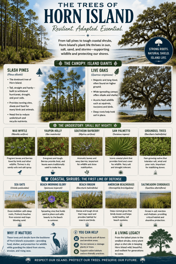
Horn Island features maritime pine-oak woodlands, with trees anchoring portions of the interior ridge and surrounding many of its freshwater lagoons. These woods make the center of the island appear dramatically different from the open beaches that most boaters see.
The forest is shaped by difficult conditions. Trees must tolerate:
- Salt carried inland by Gulf winds
- Nutrient-poor sandy soil
- Intense summer heat
- Periodic drought
- Tropical storms
- Saltwater flooding
- Shifting dunes
- Strong winds
Only hardy coastal species can survive these conditions.
Slash Pines
Slash pines (Pinus elliottii) are among the most prominent trees in Horn Island’s interior woodlands. They grow along stabilized sand ridges and around some of the freshwater ponds.
Their height gives birds elevated nesting, hunting and observation points. Ospreys, bald eagles and other large birds may use the island’s trees for roosting or nesting.
Visitors may also see weathered dead trunks standing beside living pine forests. These pale, sun-bleached trunks—sometimes described as ghost trees—are reminders of earlier hurricanes, storm surge, saltwater intrusion and shoreline migration.
A stand of trees that survives for decades can be severely damaged when a major hurricane carries saltwater across the narrow island. Some trees recover, while others die and remain standing until wind and decay eventually bring them down.
Live Oaks
Live oaks (Quercus virginiana) are scattered through parts of the maritime forest. Unlike the enormous spreading live oaks found along the mainland coast, Horn Island’s trees may be shorter, windswept or irregularly shaped.
Their growth reflects decades of exposure to:
- Salt-laden wind
- Blowing sand
- Tropical weather
- Limited freshwater
- Storm surge
The twisted forms of these trees are part of the island’s visual character. They demonstrate how vegetation adapts to one of the Gulf Coast’s most demanding environments.
Understory Trees and Coastal Shrubs
Below and around the pine and oak canopy, visitors may encounter hardy coastal shrubs and smaller woody plants, including:
- Wax myrtle
- Yaupon holly
- Saw palmetto
- Groundsel bush, also called sea myrtle
- Other salt- and wind-tolerant shrubs
These plants create dense cover for birds and other wildlife. Their root systems also hold sand and organic material in place, helping portions of the island resist everyday wind erosion.
Vegetation communities within Gulf Islands National Seashore commonly include slash pine growing above plants such as saw palmetto, yaupon and wax myrtle, although the exact mix changes with elevation, soil moisture, storm exposure and salinity. (National Park Service)
Why the Trees Matter
Horn Island’s trees are not merely scenic. They perform several important ecological functions.
They Help Stabilize Interior Dunes
Roots bind loose sand and help stabilize older dune ridges. Trees cannot stop a major hurricane from overwashing the island, but healthy vegetation can reduce ordinary wind erosion and hold portions of the interior landscape together.
They Protect Freshwater Habitat
Vegetated dunes and wooded ridges help define the depressions where rainwater collects. Shade from trees and shrubs can also reduce evaporation around smaller ponds.
The island’s freshwater supply is essential to alligators, birds, mammals, reptiles and insects. Without recurring rainfall and the interior landscape capable of retaining it, Horn Island could not support the same variety of wildlife.
They Provide Bird Habitat
Trees offer nesting, roosting and resting places for resident and migratory birds. Horn Island lies along important coastal migration routes, and its protected shoreline, dunes, marshes and interior vegetation provide places for birds to feed and recover.
The National Park Service considers the barrier islands’ shorelines and adjacent dunes crucial habitat for nesting, feeding and resting shorebirds, including species that receive special management attention. (National Park Service)
They Provide Shelter from Weather
Dense vegetation offers wildlife protection from strong wind, summer heat and predators. Fallen trees and branches also create habitat for insects, reptiles and small animals.
A Wilderness, Not a Developed Beach
Horn Island and Petit Bois Island are federally designated wilderness areas within Gulf Islands National Seashore. That status is intended to preserve their natural ecosystems and opportunities for solitude. (National Park Service)
There are no paved roads, hotels, restaurants, stores, drinking-water stations or developed campgrounds on Horn Island. Its undeveloped condition is one reason its maritime forest, freshwater wetlands and wildlife remain so significant.
Visitors should also remember that the vegetation is vulnerable. Walking or camping directly on dunes or planted areas can damage roots that help hold the island together. National Park Service rules require wilderness camping to occur on suitable beach areas rather than on dunes or vegetation. (National Park Service)
How Geography Creates Alligator Habitat
Horn Island’s alligators are not generally living on the exposed Gulf beach. Their primary habitat is associated with the island’s interior freshwater ponds, wooded wetlands and protected lowlands.
The island gives them several things they need:
- Freshwater supplied by rain
- Warm temperatures
- Aquatic prey
- Dense vegetation
- Quiet areas with little human activity
- Routes between ponds and marshes
- Access to surrounding coastal waters when moving elsewhere
The narrow island places these freshwater habitats surprisingly close to saltwater, but the dunes and maritime forest create a distinct interior environment.
This is also why most visitors never see an alligator. Boaters usually stay along the western or southwestern beaches, while the alligators generally remain near quieter ponds farther inside the island.
A Landscape That Never Stands Still
Horn Island may look permanent from the mainland, but it is continually moving and changing. Sand is eroded from some areas and deposited in others. Storms wash across low sections, ponds change size, trees die, new dunes form and the shoreline migrates.
USGS research documents this ongoing westward movement and changing seafloor around Horn Island. (U.S. Geological Survey)
Its low elevation makes the island especially vulnerable. At only about 20 feet above sea level at its highest point—and much lower across most of its surface—storm surge can wash across extensive sections of the island. (National Park Service)
Yet that ability to change is also part of how a barrier island survives. Horn Island absorbs enormous amounts of wave and storm energy, loses sand in one location and rebuilds in another. Its ponds, dunes and forests may shift, but together they continue supporting one of Mississippi’s richest coastal wilderness environments.
I think this deserves its own major chapter. Rather than simply listing species, let’s make it a narrative that explains why Horn Island supports so much wildlife. Readers—and Google—will find it much more engaging.
Life on Horn Island — One of the Gulf Coast’s Richest Wildlife Sanctuaries
Few places on the Mississippi Gulf Coast support as much wildlife as Horn Island. Although many visitors arrive for the beautiful beaches, boating, fishing, or camping, the island is actually one of the most biologically diverse environments in the northern Gulf of Mexico.
The combination of freshwater ponds, maritime forests, dunes, salt marshes, tidal flats, beaches, and surrounding Gulf waters creates a remarkable variety of habitats packed into a relatively small barrier island. Because Horn Island remains largely undeveloped, wildlife continues to thrive much as it has for centuries.
Whether you’re walking the beaches, exploring the interior, or arriving by boat, you’ll likely encounter birds, marine life, reptiles, or mammals that call this remarkable island home.
Reptiles and Amphibians
The island’s warm climate, freshwater ponds, marshes, and forests provide ideal habitat for a variety of reptiles and amphibians.
American Alligators
The American alligator is undoubtedly Horn Island’s most famous resident.
Most alligators live around the island’s interior freshwater ponds and lagoons where they have access to fresh water, fish, turtles, birds, and other prey. They generally avoid the busy beaches and boating areas, which is why many visitors spend an entire day on the island without ever seeing one.
Unlike the popular southwestern beach where boaters gather, the alligators prefer the quiet interior wetlands where human activity is minimal.
Snakes
Horn Island supports several snake species, most of which are harmless and help control rodent populations.
Common non-venomous snakes include:
- Southern Black Racer
- Gulf Salt Marsh Snake
- Corn Snake
- Eastern Rat Snake
Venomous species include:
- Eastern Diamondback Rattlesnake
- Cottonmouth (Water Moccasin)
Like the alligators, snakes generally avoid people whenever possible.
Turtles
Horn Island provides important habitat for both marine and freshwater turtles.
Protected sea turtles nesting on the island include:
- Atlantic Loggerhead
- Green Sea Turtle
- Kemp’s Ridley Sea Turtle
Freshwater and terrestrial species include:
- Mississippi Redbelly Turtle
- Box Turtles
- Mud Turtles
Sea turtle nests are protected each nesting season, and visitors should never disturb marked nesting areas.
Frogs and Toads
The freshwater ponds become especially active after spring and summer rains.
Common amphibians include:
- Green Treefrog
- Squirrel Treefrog
- Pig Frog
- Southern Leopard Frog
Their nighttime chorus is one of the sounds that makes camping on Horn Island such a unique experience.
Birds: A World-Class Birding Destination
Horn Island is considered one of the premier birding destinations along the northern Gulf Coast.
More than 280 bird species have been documented on Horn Island and throughout Gulf Islands National Seashore.
Because the island contains beaches, marshes, freshwater ponds, pine forests, and maritime woodlands, it provides habitat for both year-round residents and migratory birds crossing the Gulf of Mexico.
Each spring and fall, exhausted songbirds arrive after flying hundreds of miles across open water, making Horn Island an internationally important migration stop.
Ospreys and Other Raptors
One of the island’s signature sights is the osprey.
These magnificent fish-eating hawks frequently build large stick nests atop dead pine trees overlooking the freshwater ponds.
Other birds of prey include:
- Bald Eagles
- Peregrine Falcons
- American Kestrels
- Northern Harriers
- Barn Owls
Watching an osprey dive into one of the ponds or Mississippi Sound to catch a fish is one of Horn Island’s unforgettable wildlife experiences.
Shorebirds and Beach Nesters
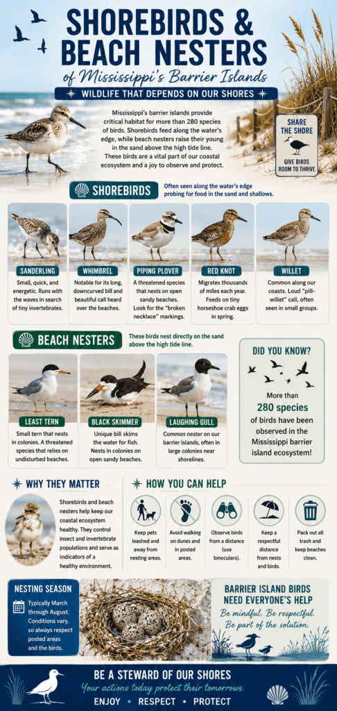
Horn Island contains some of the Gulf Coast’s most important nesting habitat for beach birds.
Visitors may encounter:
- Least Terns
- Royal Terns
- Sandwich Terns
- Gull-Billed Terns
- Black Skimmers
- American Oystercatchers
- Wilson’s Plovers
- Snowy Plovers
- Piping Plovers
- Willets
- Spotted Sandpipers
During nesting season, portions of the beach may be temporarily closed to protect these sensitive nesting colonies.
Respecting these closures helps ensure future generations of these birds continue to thrive.
Pelicans, Herons and Wading Birds
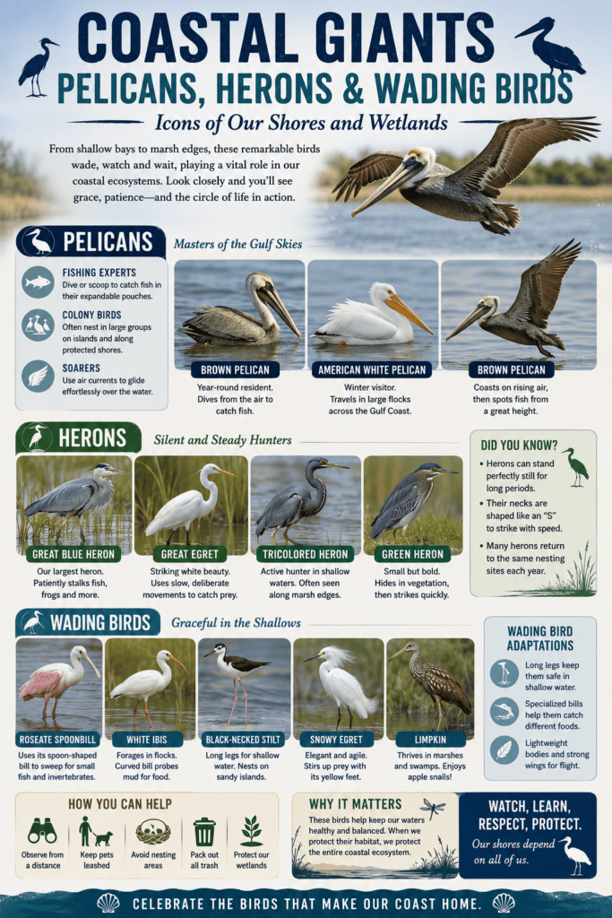
The marshes and shallow lagoons are filled with graceful wading birds.
Common species include:
- Brown Pelicans
- American White Pelicans (winter)
- Great Blue Herons
- Great Egrets
- Snowy Egrets
- Reddish Egrets
- Tricolored Herons
- Black-Crowned Night-Herons
- White Ibises
- Wood Storks
- Clapper Rails
These birds feed throughout the marshes and tidal flats, often providing spectacular photography opportunities.
Migratory Songbirds
One of Horn Island’s least appreciated wildlife spectacles occurs every spring and fall.
After flying across the Gulf of Mexico, thousands of migratory songbirds land in the maritime forests to rest and feed.
Birders often search for:
Warblers
- Hooded Warbler
- Pine Warbler
- Prairie Warbler
- Cape May Warbler
- Kentucky Warbler
- Black-and-White Warbler
- Prothonotary Warbler
Other Migrants
- Scarlet Tanager
- Painted Bunting
- Indigo Bunting
- Rose-breasted Grosbeak
- Gray Catbird
- Gray-cheeked Thrush
- Red-eyed Vireo
- Great Crested Flycatcher
- Acadian Flycatcher
For many birdwatchers, migration season is the best time to visit Horn Island.
Mammals
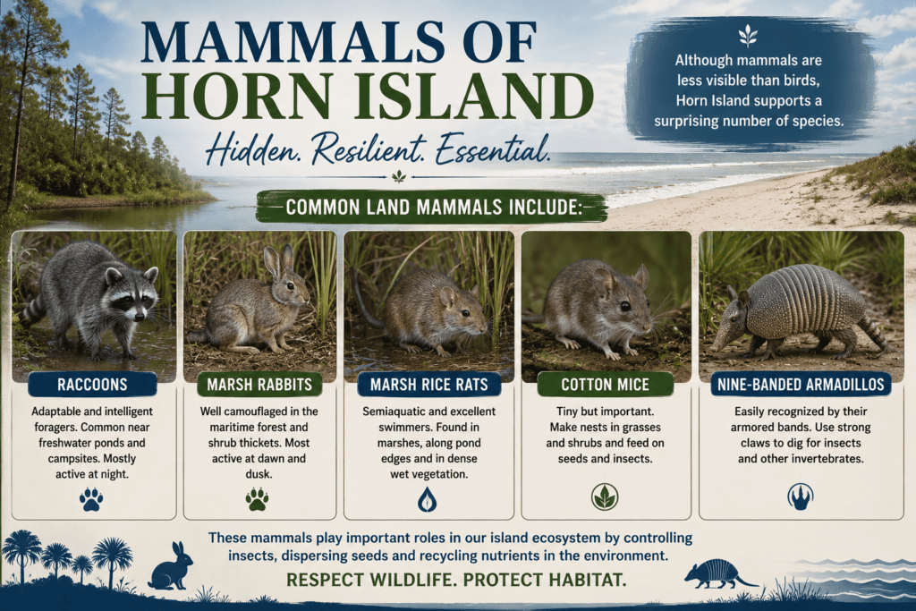
Although mammals are less visible than birds, Horn Island supports a surprising number of species.
Common land mammals include:
- Raccoons
- Marsh Rabbits
- Marsh Rice Rats
- Cotton Mice
- Nine-Banded Armadillos
Raccoons are especially common and quickly learn to investigate unattended campsites.
Visitors should never feed wildlife or leave food unsecured.
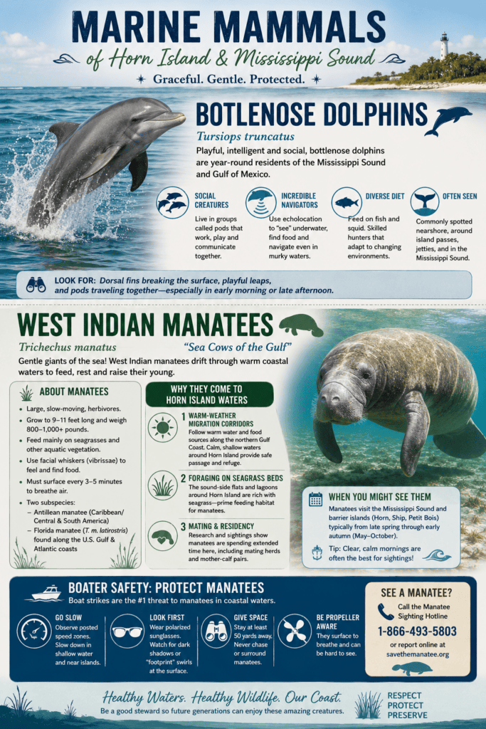
Marine Mammals
The surrounding waters are equally impressive.
Boaters frequently encounter:
- Bottlenose Dolphins
During warmer months, lucky visitors may even spot:
- West Indian Manatees
Seeing dolphins feeding just offshore while anchored at Horn Island is one of the highlights of many boating trips.
Marine Life Beneath the Surface
The shallow waters surrounding Horn Island serve as nursery grounds for many Gulf fish species.
Popular sport fish include:
- Speckled Trout
- Red Drum (Redfish)
- Southern Flounder
- Black Drum
- Mullet
- Sheepshead
Small sharks are also occasionally encountered in surrounding waters.
These productive fisheries are one reason Horn Island remains a favorite destination for anglers.
Crabs and Other Invertebrates
Even the sand is alive.
Visitors often notice:
- Ghost Crabs racing across the beach after sunset.
- Fiddler Crabs waving oversized claws throughout the marshes.
- Horseshoe Crabs visiting shallow beaches during spawning periods.
Together with countless insects, shrimp, oysters, and other invertebrates, these creatures form the foundation of Horn Island’s food web.
A Living Wilderness
Horn Island remains one of the few places on the Mississippi Gulf Coast where visitors can experience an ecosystem that functions much as it did centuries ago.
Its beaches, maritime forests, freshwater ponds, marshes, and surrounding Gulf waters support an extraordinary diversity of wildlife that few places along the northern Gulf can match.
Whether you’re hoping to photograph an osprey carrying a fish, hear frogs calling after sunset, watch dolphins feeding offshore, or simply catch a glimpse of one of the island’s elusive alligators, Horn Island offers a true wilderness experience that continues to inspire visitors year after year.
Author’s Tip
“One of my favorite wildlife experiences at Horn Island is watching bottlenose dolphins feeding just offshore while anchored on the southwest beach. Early in the morning, it’s not unusual to see pelicans diving for fish while ospreys circle overhead. Even if you never see one of the island’s alligators, you’ll almost certainly come home with memorable wildlife encounters.”
That kind of firsthand observation strengthens the article’s experience-based perspective and complements the factual information throughout the chapter.
What People Often Ask About Horn Island Alligators: The Basics
Are there really alligators on Horn Island?
Yes. American alligators live on Horn Island, particularly around the freshwater ponds, marshes, and wetlands in the island’s interior. While many visitors spend their day enjoying the beaches, boating, or fishing, the alligators generally remain away from the shoreline and areas with regular human activity.
Why are there alligators on a barrier island?
Horn Island receives abundant rainfall that collects in dozens of freshwater ponds throughout the island. These ponds provide drinking water, shelter, and food such as fish, turtles, birds, and other wildlife. The island’s undeveloped landscape creates ideal habitat for alligators.
How do alligators get to Horn Island?
Although American alligators prefer freshwater, they can tolerate saltwater for short periods. They are strong swimmers and are known to travel between coastal marshes, rivers, and barrier islands. Some likely swim across Mississippi Sound during favorable weather, while others may be carried naturally by storm tides or move between islands over time.
Are alligators permanent residents of Horn Island?
Some remain on the island for long periods, while others may leave as freshwater supplies change. Their numbers fluctuate depending on rainfall, drought conditions, available food, and changing water levels.
Are Horn Island alligators dangerous?
Like all wild animals, they deserve respect. However, there have been no documented attacks on visitors on Horn Island. Most alligators avoid people whenever possible and will usually retreat if left alone.
This would fit nicely into the “Getting to Horn Island” chapter. I would present it like this:
How Far Is Horn Island from the Mainland?
One of the reasons Horn Island feels so remote is that it lies well offshore in Mississippi Sound. Although you can often see the island from the mainland on a clear day, reaching it requires a boat and a crossing over open water.
The distance depends on where you launch and where you plan to anchor.
From Ocean Springs Harbor
If you depart from the public harbor in Ocean Springs, the trip to the western or central portion of Horn Island is approximately:
- 10–12 nautical miles
- 11.5–14 statute miles
After leaving the harbor, you’ll follow the marked channel before entering the open waters of Mississippi Sound. On calm days, the crossing is enjoyable and offers beautiful views of the Mississippi coastline, passing boats, dolphins, pelicans, and occasionally ospreys hunting for fish.
If you launch farther west or south, such as near Belle Fontaine, the open-water crossing can be reduced to approximately 7–9 statute miles.
From Pascagoula Harbor
Launching from Pascagoula provides one of the shortest routes to Horn Island.
The trip to the eastern portion of the island is approximately:
- 7–9 nautical miles
- 8–10 statute miles
Boaters departing from Pascagoula should remain aware of commercial ship traffic and the navigation channels leading into the Port of Pascagoula before crossing Mississippi Sound toward Horn Island Pass.
How Long Does the Trip Take?
Travel time depends on your boat and weather conditions.
Approximate travel times are:
| Boat Speed | Estimated Travel Time (Ocean Springs) |
|---|---|
| 15 mph | 45–60 minutes |
| 25 mph | 30–40 minutes |
| 35 mph | 20–30 minutes |
The crossing should always be planned according to the weather forecast. Even though Mississippi Sound is generally protected by the barrier islands, strong southerly winds can quickly create rough conditions.
A Personal Observation
From my experience, the trip from Ocean Springs is one of the most enjoyable boat rides on the Mississippi Gulf Coast. When the wind is light, Mississippi Sound is often calm, making for a relaxing cruise to the island. As Horn Island comes into view, the white sand beaches, rolling dunes, and pine-covered interior create an unforgettable first impression.
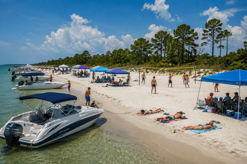
One of my favorite parts of the trip is approaching the southwestern end of Horn Island, where dozens of local boaters often spend summer weekends.
Boats line the beach while families set up shade canopies, grills, and beach chairs for the day. From there, it’s just a short walk across the island to the Gulf beach, where visitors can enjoy the surf and one of the most beautiful stretches of undeveloped shoreline on the Mississippi Gulf Coast.
Boating Safety Tip: Before crossing to Horn Island, always check the marine weather forecast, ensure you have sufficient fuel for the round trip, wear U.S. Coast Guard-approved life jackets, carry a VHF radio or other reliable means of communication, and let someone know your float plan. Weather on Mississippi Sound can change quickly, and there are no services available on Horn Island if you experience mechanical problems or run short of supplies.
Here is a long-form section that is optimized for your cornerstone article while naturally repeating the keyphrase Horn Island Mississippi throughout.
Walter Anderson: The Artist Who Made Horn Island Mississippi Famous
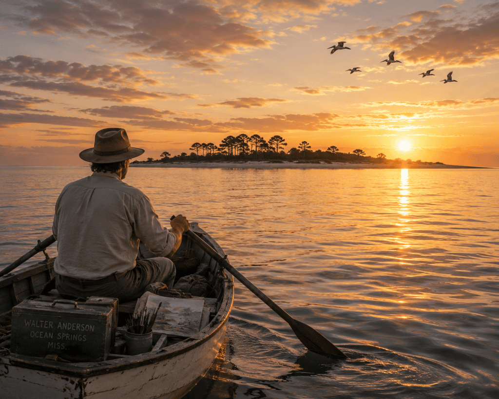
If one person became synonymous with Horn Island Mississippi, it was Walter Inglis Anderson.
Long before drones, digital cameras, and social media introduced millions of people to remote wilderness destinations, Walter Anderson quietly crossed the Mississippi Sound alone in a small wooden skiff, making the journey from Ocean Springs to Horn Island Mississippi hundreds of times.
He wasn’t searching for treasure.
He wasn’t seeking fame.
He wasn’t looking for solitude simply to escape society.
He came because Horn Island Mississippi offered something no other place could—a living wilderness where every sunrise, every bird, every wave, every tree, and every storm became part of an endless work of art.
Today, Walter Anderson’s paintings, journals, sketches, and watercolors preserve a remarkable record of Horn Island Mississippi during the 1940s through the 1960s. His work transformed a remote barrier island into one of America’s great artistic landscapes while documenting one of the Gulf Coast’s most pristine ecosystems. (National Park Service)
Who Was Walter Anderson?
Walter Inglis Anderson was born in 1903 in New Orleans but grew up in nearby Ocean Springs, Mississippi, where his lifelong fascination with the natural world began.
From an early age he demonstrated extraordinary artistic ability.
Yet Anderson became far more than simply a painter.
He was also:
- A naturalist
- A writer
- A philosopher
- A printmaker
- A muralist
- A keen observer of wildlife
- One of America’s finest watercolor artists
His formal education included studies at the prestigious Pennsylvania Academy of the Fine Arts, followed by travel in Europe that broadened both his artistic technique and his understanding of classical art. Eventually, however, he chose to return to the Mississippi Gulf Coast rather than remain in larger art centers. (Mississippi Encyclopedia)
(Insert large portrait of Walter Anderson.)
Why Horn Island Mississippi?
Many artists paint mountains.
Others paint cities.
Walter Anderson chose Horn Island Mississippi.
The island offered everything he loved.
Unlike the mainland, Horn Island Mississippi remained almost completely untouched.
There were:
- miles of undeveloped beaches
- towering dunes
- freshwater ponds
- maritime forests
- slash pine groves
- marshes
- birds
- turtles
- alligators
- dragonflies
- ghost crabs
- shorebirds
- shells
- changing tides
- changing weather
- incredible light
Most importantly…
There were almost no people.
The island became a place where Anderson believed he could better understand both nature and humanity.
One of his journal entries beautifully captures his affection for the island:
“My love was afar, the island.” (Walter Anderson MoA)
The Twelve-Mile Journey
Perhaps the most remarkable part of the Walter Anderson story isn’t what he painted.
It’s how he reached Horn Island Mississippi.
Before every trip he packed:
- watercolor paints
- brushes
- paper
- journals
- food
- drinking water
- camping equipment
Everything fit inside a small wooden rowing skiff.
Then he pushed away from Ocean Springs.
The journey covered roughly twelve miles across the Mississippi Sound. Over roughly the last twenty years of his life, he made the crossing 100 times or more. (National Park Service)
Think about that.
No GPS.
No outboard motor.
No VHF radio.
No cell phone.
No Coast Guard weather app.
Only a pair of oars, experience, determination, and an intimate understanding of the Gulf.
Even today, experienced boaters respect the Mississippi Sound because weather conditions can change rapidly.
Walter Anderson crossed it alone.
Again.
And again.
And again.
Living on Horn Island Mississippi
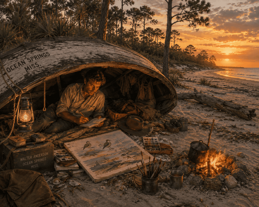
Once Walter Anderson reached Horn Island Mississippi, civilization disappeared behind him.
His accommodations were remarkably simple.
He often:
- camped on the beach
- slept beneath an overturned boat
- collected rainwater
- cooked fish
- battled mosquitoes
- endured summer heat
- survived tropical storms
Sometimes he remained on Horn Island Mississippi for weeks before returning home for supplies. His routine was simple: rise with the sun, explore, observe, sketch, paint, write in his journals, and repeat the process day after day. (National Park Service)
Horn Island Mississippi Became a Living Laboratory
Walter Anderson wasn’t merely painting landscapes.
He was documenting an ecosystem.
His journals and artwork captured nearly every aspect of life on Horn Island Mississippi.
Subjects included:
- pelicans
- herons
- shorebirds
- ospreys
- egrets
- alligators
- turtles
- ghost crabs
- dragonflies
- butterflies
- wildflowers
- marsh grasses
- slash pines
- live oaks
- maritime forests
- dunes
- freshwater ponds
- fish
- clouds
- lightning
- sunsets
- moonlight
- hurricanes
Every day offered something new.
He once wrote:
“One image succeeds another with surprising regularity on Horn Island.” (National Park Service)
For Anderson, the island itself became his studio.
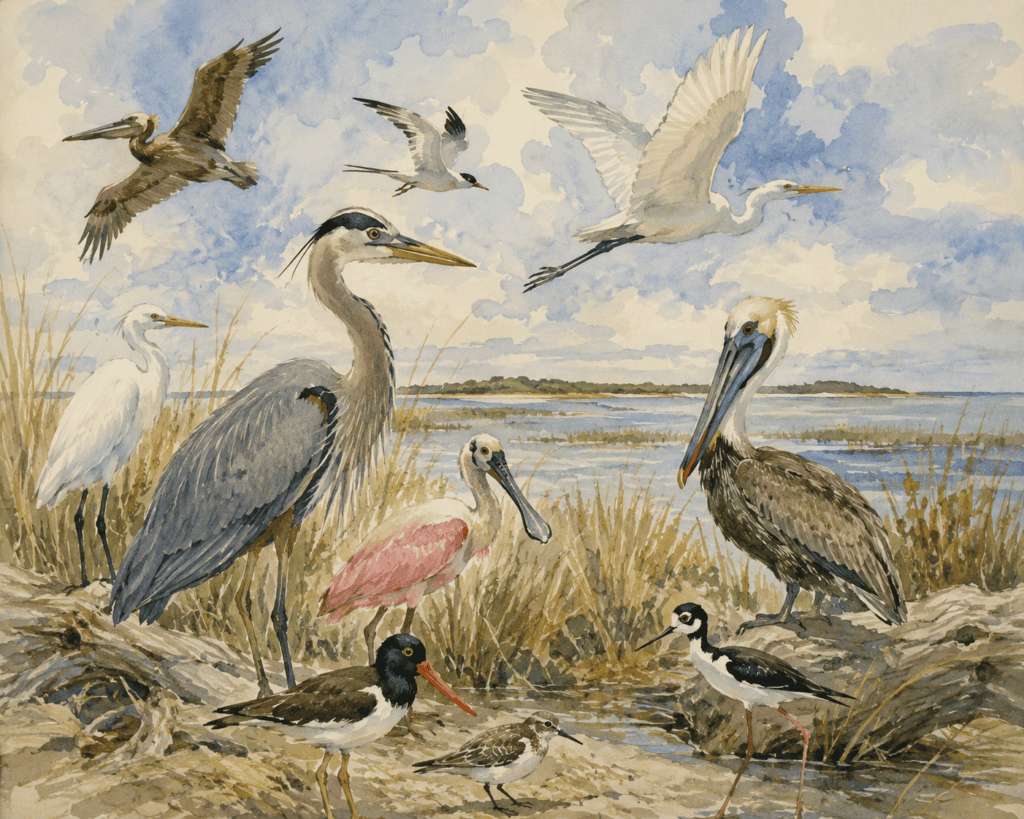
The Horn Island Logs
Walter Anderson’s journals—published later as The Horn Island Logs—are every bit as important as his paintings.
Rather than simply recording personal thoughts, they became an extraordinary scientific and artistic record of Horn Island Mississippi.
Readers find observations about:
- weather patterns
- tides
- migrating birds
- flowering plants
- insects
- reptiles
- marine life
- water levels
- changing seasons
- daily sketches
- philosophical reflections
Today these journals provide historians, artists, and naturalists with one of the most detailed firsthand accounts ever written about Horn Island Mississippi during the mid-twentieth century. (National Park Service)
Walter Anderson’s Horn Island Mississippi Today
One of the remarkable things about visiting Horn Island Mississippi today is how recognizable much of it remains.
Visitors can still stand on many of the same beaches.
Walk among similar dunes.
See the freshwater ponds.
Explore the maritime forest.
Watch pelicans soar overhead.
Listen to the same wind moving through the slash pines.
Of course, time has changed the island.
Hurricanes have reshaped shorelines.
Trees have grown or disappeared.
Sandbars have shifted.
Yet anyone familiar with Anderson’s paintings immediately recognizes the landscape.
The wilderness that inspired him still survives.
Visit the Walter Anderson Museum of Art
If you plan to visit Horn Island Mississippi, make time for the Walter Anderson Museum of Art in Ocean Springs.
The museum houses one of the world’s finest collections of Anderson’s work, including:
- original watercolors
- journals
- block prints
- murals
- pottery
- Horn Island sketches
- personal artifacts
Viewing the artwork before—or after—a trip to Horn Island Mississippi creates an entirely new appreciation for the island and the extraordinary artist who devoted so much of his life to documenting it. (Walter Anderson MoA)
Walter Anderson’s Lasting Legacy
Without Walter Anderson, Horn Island Mississippi might have remained known only to fishermen, boaters, and local residents.
Instead, his paintings introduced generations of people to one of America’s last great barrier-island wildernesses.
His artwork transformed Horn Island Mississippi into an icon of American nature art while preserving an irreplaceable visual record of the Gulf Coast’s plants, wildlife, weather, and landscapes.
Today, artists, photographers, conservationists, birdwatchers, historians, and visitors continue to make the journey across Mississippi Sound, hoping to experience the same beauty that inspired Walter Anderson more than seventy years ago.
Few artists have ever become so closely identified with a single place.
For Horn Island Mississippi, Walter Anderson was more than an artist.
He became its storyteller, its historian, its naturalist, and its greatest ambassador.
This section is naturally optimized for the keyphrase “Horn Island Mississippi” while remaining readable and suitable for a cornerstone article. It also provides strong transition points for your planned gallery of Anderson paintings, his skiff illustration, the museum callout, and the Horn Island history timeline.
Camping on Horn Island: A True Wilderness Experience
For many visitors, the best way to experience Horn Island is to spend the night. As the day boaters head back to the mainland, the island becomes remarkably quiet, offering one of the few places on the Mississippi Gulf Coast where you can enjoy a true wilderness camping experience.
One of the best parts is that primitive camping on Horn Island is free. There are no campground fees, reservations for small groups, or developed campsites. Instead, you’ll enjoy a night under the stars with the sound of Gulf waves in the background and some of the darkest skies along the Mississippi coast.
Because Horn Island is part of the Gulf Islands National Seashore and is designated as federal wilderness, campers are expected to practice Leave No Trace principles and follow National Park Service regulations designed to protect this unique environment.
Paste this into a **WordPress Custom HTML block**. I framed the stories clearly as folklore and local legend rather than documented paranormal events. ```html
Horn Island is not part of Mississippi’s mainstream ghost-tour circuit, but centuries of isolation, shipwrecks, hurricanes and secluded island history have inspired eerie tales, regional folklore and ghostly rumors along the Gulf Coast.
Beginning in 1874, Horn Island was home to a wooden lighthouse that helped guide ships through Horn Island Pass and into the Mississippi Sound.
Regional maritime legend tells of a lighthouse keeper who died during one of the destructive Gulf hurricanes of the late 19th century. According to the story, his spirit still watches the shallow water and dunes near the former lighthouse site on the island’s eastern end.
Horn Island’s strategic location near Gulf shipping routes has long connected it in local folklore with Spanish sailors, privateers and pirates.
Gulf Coast storytellers have passed down tales of buried Spanish gold and hidden pirate chests concealed among the island’s interior dunes, pine groves and lagoons.
Artist Walter Inglis Anderson repeatedly rowed from Ocean Springs to Horn Island, where he camped alone and painted the island’s wildlife, storms, plants and changing light.
His writings often describe the island in deeply spiritual and poetic terms. The wind, shadows, birds and changing weather sometimes seemed to him like living forces rather than ordinary parts of the landscape.
Horn Island is uninhabited, accessible only by boat and protected as a wilderness area. Once the last boat leaves and darkness settles over the island, ordinary sounds can become unfamiliar and unsettling.
- Phantom Footprints: Campers sometimes describe finding fresh footprints in isolated dunes far from any visible boat. In the stories, the tracks disappear at the edge of a marsh or pine thicket.
- Disembodied Murmurs: Sound can travel surprising distances across still water. Visitors have reported hearing what seemed like faint conversations, singing or voices drifting across lagoons when no one else appeared to be nearby.
- Lights Across the Water: Distant boats, stars, reflections and changing weather can create unusual lights along the horizon, sometimes inspiring stories of lanterns, lost vessels or unseen visitors.
Isolation, darkness, fog, shifting water, animal sounds and the absence of artificial light can make Horn Island feel mysterious after sunset. Whether visitors believe the legends or simply enjoy a good Gulf Coast story, the island’s quiet wilderness provides the perfect setting for imagination to take over.
What Makes Camping on Horn Island Special?
Unlike developed campgrounds, Horn Island offers a completely natural experience. There are no RV hookups, picnic tables, restrooms, or convenience stores—just miles of undeveloped beaches, maritime forests, freshwater ponds, and wildlife.
Many campers arrive in the morning by boat, spend the day enjoying the island, and then settle in for a peaceful evening as the crowds disappear.
Popular camping activities include:
- 🎣 Fishing from the beach or your boat.
- 🐬 Watching dolphins feeding offshore.
- 🦅 Bird watching, especially during spring and fall migrations.
- 🚤 Exploring the shoreline by boat.
- 🏖 Swimming in the Gulf of Mexico or relaxing along the calm waters of Mississippi Sound.
- 🦀 Walking the beach looking for shells and ghost crabs after sunset.
- 📸 Wildlife and nature photography.
- 🌅 Watching spectacular sunrises and sunsets.
- 🔥 Enjoying a beach barbecue with family and friends.
- ⭐ Stargazing under exceptionally dark skies with very little light pollution.
For many visitors, simply sitting around a small campfire listening to the surf is reason enough to make the trip.
Did you know that diving is popular around Horn Island? The Gulf waters are warm during much of the year and can offer clear underwater views, making the area appealing for wreck exploration, marine-life observation and underwater photography.
Watch the Arcturus Wreck VideoCamping Permits
The National Park Service keeps the permit process simple.
Groups of Fewer Than 10 People
No camping permit is required.
Groups of 10 or More
A backcountry wilderness camping permit is required through the National Park Service.
Where Can You Camp?
Camping is limited to the open beach.
You may camp:
- On flat, open sandy beach areas.
- Above the normal wave action but below protected dune vegetation.
- Outside seasonal wildlife closure areas.
You may not camp:
- On or behind the sand dunes.
- In maritime forests.
- On vegetation.
- Within protected nesting areas for shorebirds or near active eagle or osprey nests.
These rules help protect one of the Gulf Coast’s most important wildlife habitats.
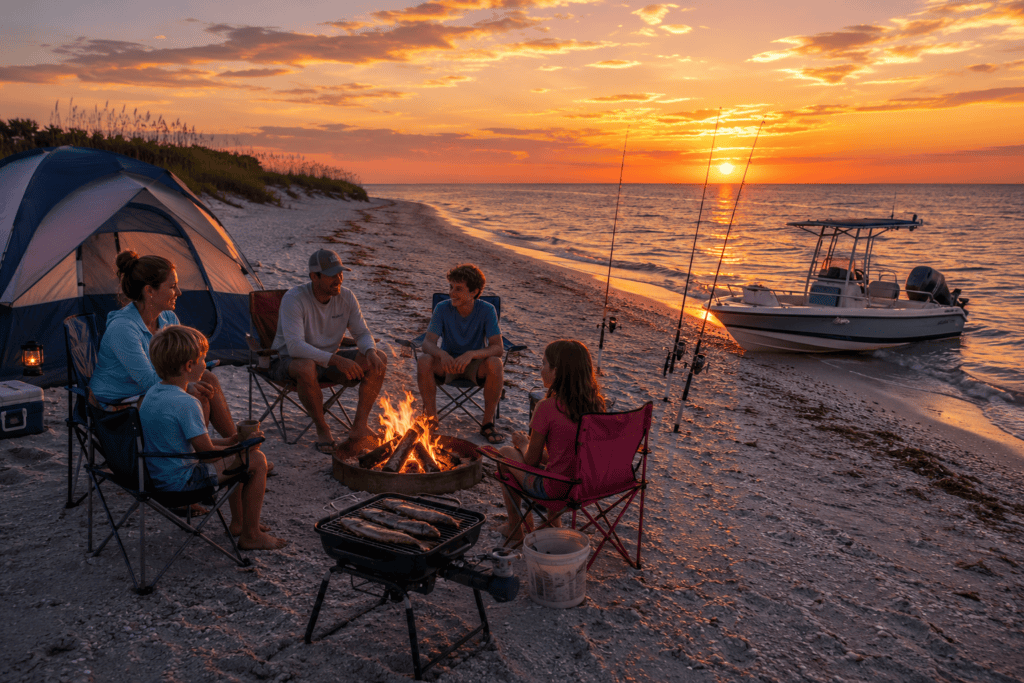
Campfires
One of the highlights of camping on Horn Island is enjoying a campfire on the beach.
However, National Park Service regulations require that:
- Fires be built only below the extreme high-tide line on open sand.
- You bring your own firewood.
- Driftwood and natural vegetation may not be collected.
- Before leaving, extinguish the fire completely and pack out any unused wood or properly disperse cooled ashes in the water as directed by park regulations.
A small beach fire while listening to the waves is one of the memorable experiences of camping on Horn Island.
Leave No Trace
Horn Island has no facilities.
That means there are:
- No restrooms.
- No trash cans.
- No potable water.
- No showers.
- No picnic tables.
- No stores.
Everything you bring to the island must leave with you.
The National Park Service asks visitors to follow a simple rule:
Pack it in. Pack it out.
Leave the island exactly as you found it so future visitors can enjoy the same wilderness experience.
Other Important Rules
Visitors should also remember:
- Pets are not allowed anywhere on Horn Island to protect nesting birds and wildlife.
- Wheeled devices, including beach carts, wagons, and wheeled coolers, are prohibited within the designated wilderness area.
- Maximum stay is 14 consecutive days, with a total limit of 42 days per calendar year.
What Should You Bring?
Since there are no services on the island, careful planning is essential.
A typical camping checklist includes:
- Plenty of drinking water (more than you think you’ll need).
- Food and cooking supplies.
- Portable grill or barbecue.
- Firewood.
- Tent and sleeping gear.
- Ice chest and ice.
- Sunscreen.
- Insect repellent.
- Flashlights or headlamps.
- First aid kit.
- Trash bags.
- Weather radio or marine weather app.
- Fully charged phone and backup battery.
- Plenty of fuel for your return trip.
If you’re boating over, it’s also wise to carry spare engine parts, an anchor, dock lines, and all required Coast Guard safety equipment.
Author’s Perspective
One of my favorite memories of Horn Island is staying after most of the day boaters have headed back to the mainland. The atmosphere changes completely. The beaches become quiet, the stars begin to fill the sky, and the only sounds are the waves, seabirds, and an occasional dolphin surfacing offshore.
Sharing a barbecue on the beach with friends, watching the sunset over Mississippi Sound, and then waking up to a peaceful Gulf sunrise is an experience that’s difficult to duplicate anywhere else on the Mississippi Gulf Coast. For those who enjoy boating, fishing, wildlife, and the outdoors, camping on Horn Island offers one of the most memorable wilderness adventures in the region.
Camping Tip: Before leaving the mainland, double-check the marine weather forecast and make sure you have enough food, drinking water, fuel, and emergency supplies for your entire stay. Once you arrive on Horn Island, there are no stores, marinas, or other services—self-sufficiency is part of the adventure.
📱 RetireCoast Wilderness Safety Tip
Your cell phone may become your most important piece of camping equipment.
Horn Island is a remote wilderness with no roads, no ranger station, no medical clinic, and no emergency facilities. If someone becomes seriously ill or injured, your phone or marine radio may be your only way to summon help.
🚨 Emergency Contacts
- Dial 911 if you have cell service.
- VHF Marine Radio – Channel 16 if cell service is unavailable.
- Emergency responders can use your phone's GPS location to help locate you.
🚤 Who May Respond?
- U.S. Coast Guard
- National Park Service Rangers
- Jackson County Marine Patrol
- Mississippi Department of Marine Resources
- Local fire and marine rescue units
🎒 Recommended Safety Gear
- Fully charged cell phone
- Portable power bank
- VHF marine radio
- First-aid kit
- Personal Locator Beacon (PLB) or satellite communicator for overnight trips
A Brief History of Horn Island
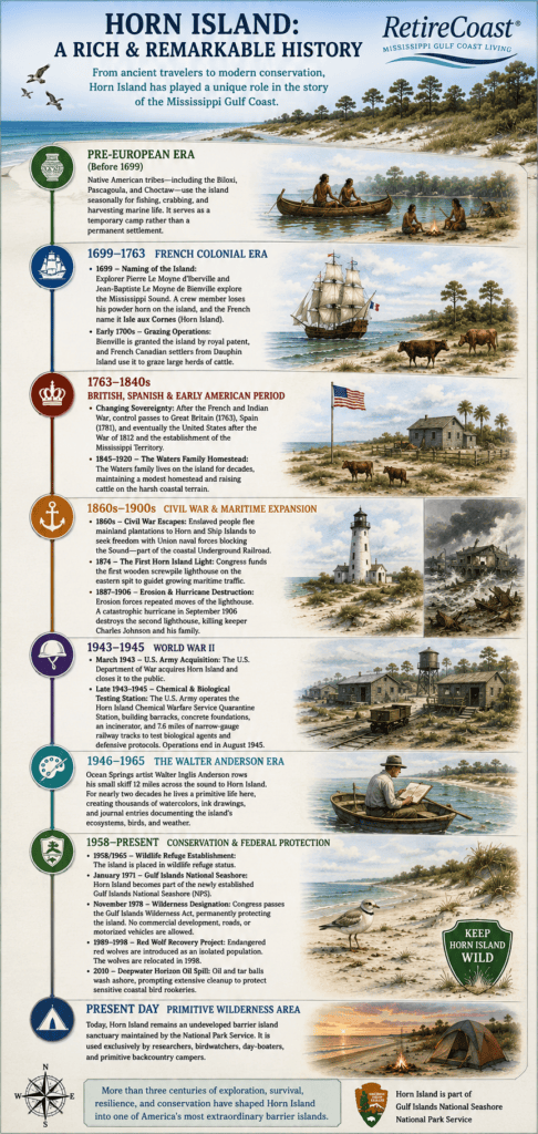
Horn Island may appear to be an untouched wilderness today, but its history stretches back thousands of years. Long before it became part of the Gulf Islands National Seashore, the island served Native Americans, European explorers, lighthouse keepers, artists, ranchers, soldiers, scientists, and conservationists. Each left a chapter in the story of one of Mississippi’s most fascinating barrier islands.
Before European Exploration (Before 1699)
For centuries before Europeans arrived, the barrier islands along the Mississippi Gulf Coast were visited by Native American tribes, including the Biloxi, Pascagoula, and Choctaw peoples.
Rather than establishing permanent villages, they used Horn Island seasonally for:
- Fishing
- Crabbing
- Collecting shellfish
- Hunting coastal wildlife
- Traveling through Mississippi Sound
Because fresh water could become scarce during dry periods and the island’s shape constantly changed with storms, Horn Island was primarily used as a temporary campsite instead of a permanent settlement.
1699: How Horn Island Got Its Name
The first recorded European exploration of Horn Island occurred in 1699, when French explorers Pierre Le Moyne d’Iberville and Jean-Baptiste Le Moyne de Bienville surveyed the Mississippi Gulf Coast while searching for the mouth of the Mississippi River.
According to tradition, one of the expedition’s crew members lost a powder horn while ashore. The French named the island Isle aux Cornes, meaning “Island of Horns,” a name that eventually evolved into today’s Horn Island.
Early French Settlement
During the early 1700s, Bienville received the island through a royal land grant.
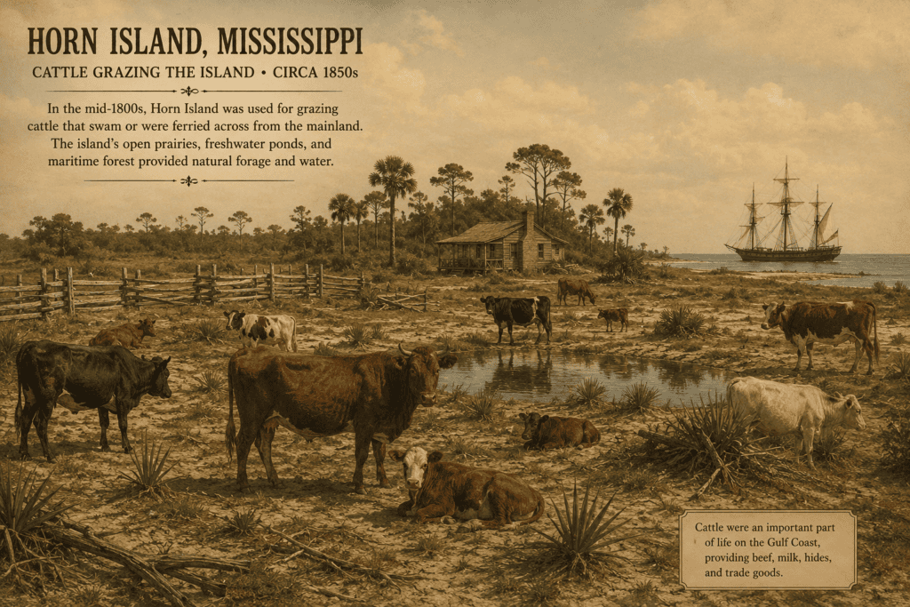
French settlers from nearby Dauphin Island soon began using Horn Island as open grazing land for cattle. With no fences and abundant grasses, livestock roamed freely across much of the island for decades.
Changing Flags Over Horn Island
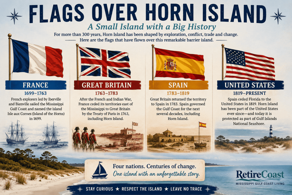
Like much of the Gulf Coast, Horn Island changed hands several times during the colonial period.
Over the next fifty years, the island was governed by:
- France
- Great Britain
- Spain
- The United States
These changes reflected the shifting political control of the Gulf Coast following the French and Indian War, the American Revolution, and the creation of the Mississippi Territory.
The Waters Family
From approximately 1845 through the early twentieth century, members of the Waters family lived on Horn Island for many decades.
Life on the island was difficult. The family raised cattle, fished the surrounding waters, and survived in one of the most isolated locations on the Mississippi coast. Their long residence demonstrated that, while challenging, life on Horn Island was possible with determination and self-sufficiency.
Horn Island During the Civil War
During the Civil War, the barrier islands became strategically important because Union naval forces controlled much of Mississippi Sound.
Historical records indicate that some enslaved people escaped plantations along the mainland and made their way to Horn Island and nearby Ship Island, where Union forces provided a pathway to freedom. As a result, the barrier islands became part of an important chapter in Gulf Coast Civil War history.
The Horn Island Lighthouse
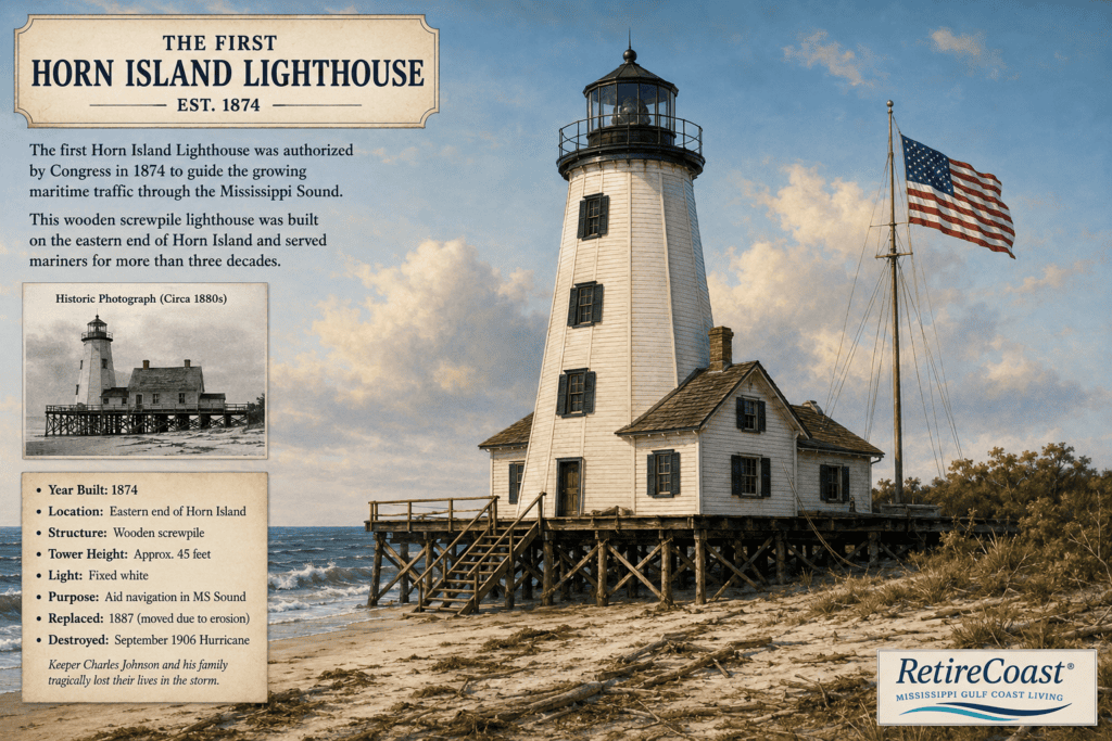
As shipping traffic increased along the Gulf Coast, Congress authorized the construction of a lighthouse on Horn Island.
- 1874: The first screwpile lighthouse was built near the island’s eastern end.
- Constant shoreline erosion repeatedly threatened the structure.
- Lighthouse keepers were forced to relocate portions of the station as the shoreline shifted.
In September 1906, a powerful hurricane destroyed the lighthouse, claiming the lives of keeper Charles Johnson and members of his family. The disaster illustrated both the power of Gulf Coast storms and the ever-changing nature of Mississippi’s barrier islands.
World War II
Horn Island played an unexpected role during World War II.
In 1943, the U.S. Department of War acquired the island and closed it to the public.
During the war years, the Army established the Horn Island Chemical Warfare Service Quarantine Station, constructing temporary buildings, railroad tracks, and research facilities to conduct biological defense testing and related military research.
When the war ended in 1945, the facilities were abandoned, and nature gradually reclaimed nearly all evidence of the military installation.
Walter Anderson’s Island
Perhaps no individual is more closely associated with Horn Island than renowned Ocean Springs artist Walter Inglis Anderson.
Beginning in the late 1940s, Anderson regularly crossed approximately twelve miles of Mississippi Sound in a small skiff to reach the island.
Often camping alone for days or weeks, he lived simply beneath an overturned boat while producing thousands of watercolor paintings, sketches, journals, and observations inspired by Horn Island’s birds, forests, beaches, wildlife, and changing weather.
Today, Walter Anderson’s work is internationally recognized and remains one of the most enduring artistic records of Mississippi’s natural heritage.
Becoming a Protected Wilderness
Following World War II, conservation efforts gradually transformed Horn Island from a working barrier island into a permanently protected natural area.
Major milestones include:
- 1958–1965: Federal wildlife protection initiatives placed the island under conservation management.
- 1971: Horn Island became part of the newly established Gulf Islands National Seashore, managed by the National Park Service.
- 1978: Congress designated Horn Island as a federal wilderness area, permanently protecting it from commercial development, roads, and motorized vehicles.
These protections preserve one of the last largely undeveloped barrier island ecosystems in the northern Gulf of Mexico.
Wildlife Conservation
Horn Island has also served as a site for wildlife restoration.
Between 1989 and 1998, endangered red wolves were introduced as part of a federal recovery program. The wolves were later relocated to avoid conflicts with increasing recreational use while continuing broader conservation efforts elsewhere.
Deepwater Horizon Oil Spill
In 2010, oil from the Deepwater Horizon disaster reached Horn Island’s beaches.
Cleanup crews worked extensively to remove oil and tar balls while protecting sensitive bird nesting areas, marshes, and wildlife habitat. The event highlighted both the vulnerability of barrier islands and their importance to Gulf Coast ecosystems.
Horn Island Today
Today, Horn Island remains one of Mississippi’s greatest natural treasures.
Protected by the National Park Service as part of Gulf Islands National Seashore, the island has no roads, bridges, hotels, restaurants, or permanent residents.
Instead, visitors experience Horn Island much as earlier generations did—by arriving by boat to explore its beaches, maritime forests, freshwater ponds, wildlife, and remarkable solitude.
More than three centuries after it received its name, Horn Island continues to serve as a living classroom where history, conservation, recreation, and nature come together on one of America’s most beautiful barrier islands.
Horn Island and the American Revolution
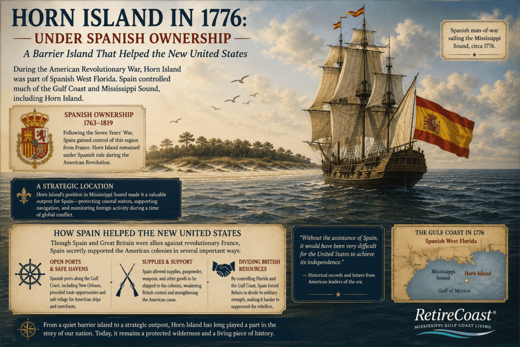
Many visitors are surprised to learn that Horn Island has a connection to the American Revolution. During the war for independence, the island was not part of the United States—it was under Spanish control as part of Spanish West Florida.
Although Spain did not formally ally itself with the thirteen colonies in 1776, it soon entered the conflict against Great Britain and became one of the most important contributors to the American cause. Spanish control of the Mississippi Gulf Coast, including Horn Island and the surrounding waters of Mississippi Sound, helped create a secure transportation network that supported the Patriot war effort.
At the time, Horn Island was one of several barrier islands guarding the approaches to the Mississippi coast. Spanish naval vessels routinely sailed these waters, protecting shipping routes and helping maintain Spanish control of the northern Gulf of Mexico.
While Horn Island itself was never the site of a major battle, its strategic location made it part of the coastal defense system that supported Spanish operations during the Revolutionary War.
A Supply Route That Helped Win Independence
One of Spain’s greatest contributions to American independence was keeping the Mississippi River open for military supplies.
Under the leadership of Bernardo de Gálvez, the Governor of Spanish Louisiana, Spain shipped desperately needed gunpowder, weapons, clothing, medicine, and other supplies up the Mississippi River to Patriot forces. These shipments became even more important after Britain attempted to isolate the colonies by controlling Atlantic ports.
Many of the Gulf Coast’s early French and Spanish settler families—ancestors of several well-known Mississippi Gulf Coast families today—worked with Spanish officials to move cargo, navigate coastal waters, and transport supplies through the Gulf Coast and up the Mississippi River.
Their local knowledge of the waterways, bays, and barrier islands helped Spain sustain an important supply network that ultimately benefited the American fight for independence.
Spain’s military campaigns under Bernardo de Gálvez also captured British forts at Baton Rouge, Natchez, Mobile, and Pensacola, forcing Britain to divert troops and resources away from the main fighting along the Atlantic seaboard. Historians widely recognize these victories as an important contribution to the eventual American victory.
Horn Island quietly witnessed this remarkable period of history. While today it is known for its pristine beaches, wildlife, and wilderness, during the Revolutionary War it overlooked the waters where Spanish ships helped protect one of the most important supply routes in North America.
Learn More
If you enjoy Revolutionary War history, these two articles explore the Gulf Coast’s often-overlooked role in America’s fight for independence:
- Mississippi Gulf Coast and the American Revolution – Discover how Mississippi’s barrier islands, waterways, and coastal settlements contributed to the Revolutionary War and why this region deserves greater recognition in American history.
- Bernardo de Gálvez: Spain, Cuba, and American Independence – Learn how Governor Bernardo de Gálvez, Spanish Louisiana, Cuba, and loyal Gulf Coast residents helped supply the Continental Army, defeat British forces along the Gulf Coast, and support the birth of the United States.
Together, these stories reveal that Horn Island was more than a beautiful barrier island—it was part of a much larger network that helped shape the history of the United States.
How Deep Is the Water Around Horn Island?
Water depth around Horn Island varies dramatically depending on which side of the island you visit. The protected northern shoreline faces the shallow waters of Mississippi Sound, while the southern beach faces the higher-energy Gulf of Mexico. At the eastern and western ends, tidal passes cut through the barrier-island chain and create deeper, faster-moving water.
These differences explain why boaters generally anchor on the north side, swimmers encounter waves on the south side, and large commercial ships can pass surprisingly close to the island’s eastern end.
Important: The depths below are general descriptions—not navigational guarantees. Sandbars and channels shift continually because of tides, storms, currents and dredging. Always use a current NOAA nautical chart, watch your depth finder and follow marked channels when navigating around Horn Island.

The North Side: Shallow Water in Mississippi Sound
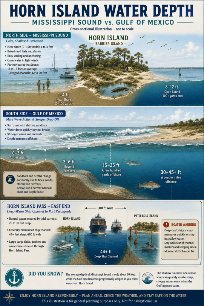
The northern side of Horn Island faces Mississippi Sound. This is generally the calmest and shallowest side of the island and the area most frequently used by recreational boaters.
Water Near the Beach
Immediately offshore, visitors commonly encounter broad sand flats and shallow shoals. Depending on the tide and the exact location, the water may be only a few feet deep for a considerable distance from shore.
Typical conditions may include:
- Approximately 1 to 4 feet of water across nearshore flats
- A sandy bottom that allows people to wade away from the beach
- Calm or nearly calm water during light winds
- Submerged sandbars that may be difficult to see from a moving boat
These shallow conditions make the north side attractive for families, swimming, anchoring and pulling smaller boats onto the beach. They also make it easy to run aground when approaching outside a suitable route.
The National Park Service recommends carrying a current nautical chart because shoals, obstructions and shallow water are common around the Mississippi barrier islands.
Farther Out in Mississippi Sound
The water gradually deepens as you travel north toward the mainland, but Mississippi Sound remains shallow compared with the open Gulf.
Much of the open Sound is generally in the range of approximately:
- 8 to 12 feet deep
- Deeper in natural depressions
- Considerably deeper inside maintained navigation channels
The shallow bottom is one reason weather can quickly make Mississippi Sound uncomfortable. When strong winds blow across relatively shallow water, the waves can become steep and closely spaced rather than forming the longer rolling swells seen offshore.

The South Side: Gulf Waves and a Faster Drop-Off
The southern side of Horn Island faces the open Gulf of Mexico. It has more wave energy, stronger surf and a different underwater profile from the calm north shore.
Walking across Horn Island from the Sound side to the Gulf side can feel like arriving at an entirely different island. The north shore may have almost no waves, while surf is breaking along the south beach.
The Surf Zone
The depth along the Gulf beach is constantly affected by waves and moving sandbars. Shallow troughs and offshore bars can form, disappear or move after storms.
Beyond the immediate surf line, the water may reach approximately:
- 3 to 6 feet deep, depending on the tide and sandbar configuration
- Greater depths beyond the first offshore bar
- Rougher water when winds blow from the south
Visitors should never assume that the bottom slopes evenly. A person may walk across a shallow bar and then suddenly step into a deeper trough.
Farther Offshore
The Gulf floor continues to slope downward as you move south of the island.
Within several hundred yards of the Gulf beach, depths may reach approximately:
- 15 to 25 feet
Several miles offshore, the water may deepen to approximately:
- 30 to 45 feet or more
The exact depths depend on the location. Official NOAA chart soundings should be used rather than estimates when navigating offshore.
The National Park Service describes the Gulf side of Mississippi’s barrier islands as a higher-energy environment than the Sound side, which helps explain its stronger waves, greater erosion and constantly changing underwater contours.
Dog Keys Pass at the Western End
Dog Keys Pass connects Mississippi Sound with the Gulf of Mexico at the western end of Horn Island.
NOAA’s Coast Pilot reports a depth of approximately 13 feet over the bar at Dog Keys Pass. That is shallower than the heavily dredged commercial channel at the island’s eastern end.
Because the pass is influenced by tidal flow, boaters may encounter:
- Stronger currents
- Shifting shoals
- Breaking waves when wind and tide oppose one another
- Water that changes depth rapidly near the bar
A pass that appears calm under one set of conditions may become difficult when the tide, wind or waves change.
Horn Island Pass and the Pascagoula Ship Channel
The eastern end of Horn Island is dramatically different from the shallow recreational beaches farther west.
Horn Island Pass separates the eastern tip of Horn Island from West Petit Bois and Petit Bois Island. This pass contains the federally maintained Pascagoula Harbor navigation channel, which allows deep-draft ships to travel between the Gulf of Mexico and Port Pascagoula.
Federal project documents describe:
- An entrance channel approximately 44 feet deep and 550 feet wide
- A channel approximately 44 feet deep and 600 feet wide through Horn Island Pass
- A sediment or impoundment basin associated with the channel system
These dimensions allow large cargo vessels, tankers and naval ships to pass through waters that would otherwise be far too shallow.
Large Ships Pass Close to Horn Island
The ship channel passes close to the island’s eastern end. Visitors in this area may see large commercial or military vessels entering and leaving Pascagoula.
Once through Horn Island Pass, the channel turns northwest across Mississippi Sound toward the port. This creates an unusual scene: a deep-draft ship traveling through a carefully maintained channel while only a short distance away the surrounding Sound may be shallow enough to strand a recreational boat.
Why Small Boats Must Avoid the Shipping Lane
A commercial ship confined to a dredged channel cannot simply turn aside for a fishing boat, kayak or pleasure craft. Large vessels may require considerable distance to slow down, and their crews may be unable to see a small boat positioned close to the bow.
Small-craft operators near the eastern end should:
- Remain well outside the marked shipping channel
- Avoid crossing directly in front of an approaching vessel
- Cross only when there is ample time and visibility
- Monitor VHF Channel 16
- Watch for powerful wakes
- Never anchor inside or near the channel
- Use extra caution around channel markers and turning areas
The Gulf Intracoastal Waterway also crosses the deep ship channel in Mississippi Sound, adding another area where recreational and commercial traffic may intersect.
Why the North and South Sides Feel So Different
Horn Island separates two very different bodies of water.
North Side
- Faces Mississippi Sound
- Broad shallow flats
- Generally calmer water
- Limited wave action during good weather
- Most popular for anchoring and beaching boats
- Greater risk of striking shoals or sandbars
South Side
- Faces the open Gulf of Mexico
- Breaking surf
- Moving offshore bars and troughs
- Faster transition into deeper water
- More erosion and wave energy
- Greater risk from surf, currents and changing weather
This contrast is one of Horn Island’s most interesting features. A visitor can anchor in calm water on the north shore, walk across the island and encounter breaking Gulf waves on the south beach.
Author’s Boating Observation
When I traveled to Horn Island from Ocean Springs, I followed marked channels for much of the trip. This is important because Mississippi Sound is shallow and contains numerous sandbars and shoals.
Although Horn Island is low-lying, it can usually be seen from the boat well before arrival. Once on the island, the mainland coastline also remains visible across Mississippi Sound under normal conditions.
My recommendation is to experience both shorelines. Most boaters spend their time along the calm north side, but walking across to the south side reveals an entirely different setting. On one side there may be almost no wave action; on the other, Gulf waves continually break against the beach.
That contrast helps explain how a narrow barrier island can provide two completely different coastal experiences within a relatively short walk.
RetireCoast Navigation Reminder: Never use approximate depth ranges from a travel article as a substitute for navigational information. Carry an updated NOAA chart, follow marked channels, use a depth finder and slow down when approaching the island. Storms can move sand and change a familiar route between visits.

What People Often Ask About the Freshwater Ponds
How deep are the freshwater ponds?
Most freshwater ponds range from about 2 to 6 feet deep, although water levels vary significantly depending on rainfall, drought, and recent storms. Some ponds become shallow during dry periods, while others expand after heavy rains.
Are the ponds connected to the Gulf of Mexico?
Most are isolated freshwater ponds formed by rainfall and natural depressions within the island. Some low areas may receive occasional saltwater during hurricanes or unusually high storm tides, but they generally remain freshwater habitats.
Can you swim in the ponds?
Swimming in the freshwater ponds is not recommended. Besides the possibility of encountering alligators, the ponds may contain soft bottoms, submerged vegetation, insects, and other wildlife. The Gulf beaches provide a much safer and more enjoyable swimming experience.
Why don’t the ponds dry up?
Rainfall regularly replenishes them. Some ponds become much smaller during extended dry periods, while others remain because they sit in lower elevations where groundwater and rainfall collect naturally.
Why are there so many ponds on Horn Island?
Barrier islands constantly change as wind, waves, storms, and shifting sand create natural depressions. Over time, rainwater fills these low areas, creating the freshwater ponds that support the island’s diverse wildlife.
How Did Alligators Get to Horn Island?
The presence of American alligators on Horn Island raises an obvious question: How did a freshwater reptile reach an island several miles from the Mississippi mainland?
The most likely answer begins in the extensive wetlands of Jackson County and the Pascagoula River Basin.
The Pascagoula River empties into Mississippi Sound northeast of Horn Island. Its lower basin contains an enormous network of freshwater swamps, marshes, oxbow lakes, bayous and tidal channels—all excellent habitat for American alligators.
Alligators also inhabit other nearby coastal systems, including the lower Escatawpa River, coastal bayous and marshes surrounding Pascagoula, Gautier and Ocean Springs. Gulf Islands National Seashore identifies the Davis Bayou area on the mainland as one of the places within the park where visitors are most likely to see an alligator.
Although no widely available scientific study appears to have tracked individual alligators from the Pascagoula River directly to Horn Island, the river delta is the most logical source for at least some of the island’s animals.
Alligators Are Strong Swimmers
Alligators are primarily freshwater animals, but they are powerful swimmers capable of traveling through rivers, estuaries, bays and coastal water.
Researchers have documented American alligators using estuarine environments where salinity changes with rainfall, tides and freshwater flow. Their presence is strongly influenced by salinity because they cannot remain indefinitely in highly saline water without returning to freshwater.
This means an alligator does not need a continuous freshwater path to reach Horn Island. It only needs conditions that permit it to cross Mississippi Sound and then find freshwater after arriving.
Horn Island provides that destination through its numerous interior ponds, wetlands and seasonally flooded depressions.
The Pascagoula River Connection
The Pascagoula River is one of the most ecologically important river systems in the United States. Unlike most large rivers, much of its flow remains unobstructed by major dams.
Its lower reaches spread into an extensive coastal delta containing:
- Freshwater swamps
- Cypress and tupelo wetlands
- Marshes
- Backwater channels
- Bayous
- Tidal creeks
- Abundant fish, turtles, birds and mammals
This environment provides food, nesting habitat and secluded territory for alligators.
From the lower river and delta, an animal moving downstream can enter Mississippi Sound. Horn Island lies directly offshore, making it a possible destination for a dispersing alligator.
The crossing would not necessarily happen in a straight line. An animal might follow marsh edges, shallow coastal water, tidal currents or temporary areas of reduced salinity before eventually reaching the island.
Heavy Rain Can Create a Fresher Mississippi Sound
The idea of a temporary freshwater corridor is useful, although it should not be imagined as a clearly defined river running across the Sound.
After prolonged rainfall or flooding, the Pascagoula River releases a large volume of freshwater into Mississippi Sound. Freshwater runoff mixes with saltwater and can substantially reduce salinity near river mouths and across portions of the Sound.
Salinity varies continually according to:
- River discharge
- Recent rainfall
- Wind direction
- Tides
- Gulf water entering through the passes
- Tropical storms
- Seasonal drought
During a major river discharge, the water between the mainland and Horn Island may become more brackish and therefore less stressful for an alligator than normal Gulf seawater.
Alligators can use brackish and estuarine habitats for limited periods, but they require access to freshwater for long-term survival. Scientific research shows that prolonged exposure to saline environments places physiological stress on American alligators.
A flood-related reduction in salinity could therefore make the journey to Horn Island easier, but it is not necessarily required for a large, healthy alligator to complete a relatively brief crossing.
Floods and Tropical Storms May Move Alligators
Flooding and tropical weather may also contribute to the arrival of alligators on the barrier islands.
During high water, alligators frequently move beyond their usual ponds and bayous. Flooded marshes connect waterways that may ordinarily be separated, giving animals more opportunities to travel.
A tropical storm or hurricane can create even more dramatic changes by:
- Flooding coastal marshes
- Connecting rivers, bayous and tidal channels
- Displacing wildlife from normal habitat
- Producing strong currents
- Lowering salinity through heavy rainfall
- Carrying floating vegetation and debris into Mississippi Sound
Some animals may enter the Sound intentionally while dispersing. Others may be displaced by floodwater or storm surge.
Horn Island itself is frequently reshaped by hurricanes and overwash. The National Park Service notes that the island is low, narrow and highly vulnerable to storm surge.
For wildlife, these storms can both destroy habitat and create new routes between mainland wetlands and the barrier islands.
Do Alligators Intentionally Swim to Horn Island?
Some probably do.
Young adult males are especially likely to travel while searching for new territory. Population pressure, competition, breeding behavior, changing water levels and food availability can all encourage alligators to move.
An alligator entering Mississippi Sound may be able to:
- Detect distant land or vegetation.
- Follow currents or shallow-water contours.
- Rest temporarily in shallow water.
- Travel during cooler or calmer conditions.
- Reach the north shore of Horn Island.
- Move inland until it finds freshwater.
Alligators are not marine reptiles, but they are capable of purposeful coastal movement. Their muscular tails make them efficient swimmers, and they may travel much farther than visitors expect.
The important distinction is that they are crossing saltwater, not living permanently in it.
Why Horn Island Can Support Them
Reaching Horn Island is only half of the story. An alligator would not remain there unless the island offered suitable habitat.
Horn Island contains freshwater and low-salinity ponds within its interior. These ponds can support:
- Fish
- Frogs
- Turtles
- Aquatic insects
- Wading birds
- Small mammals
- Marsh vegetation
- Potential nesting areas
The island’s freshwater ponds allow alligators to recover from exposure to saltwater, regulate their body chemistry, find food and establish territory.
The National Park Service describes American alligators as inhabitants primarily of freshwater swamps and marshes, rivers, lakes and smaller bodies of water.
Horn Island may be surrounded by saltwater, but parts of its interior function more like isolated freshwater wetlands.
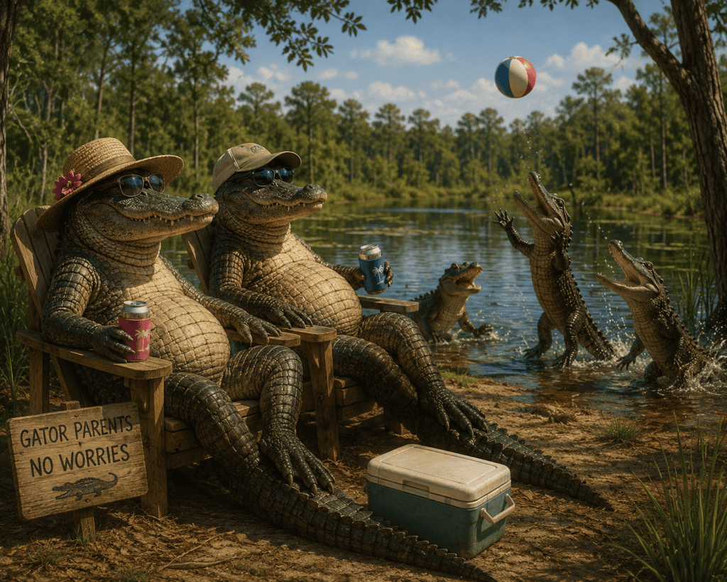
Are Some Horn Island Alligators Born There?
That is possible, but it should not be assumed without documented nest surveys.
If adult males and females occupy the island at the same time and suitable nesting habitat is available, reproduction could occur. Female alligators build nests from vegetation and soil above the waterline, usually near freshwater habitat.
Young alligators would then be born on Horn Island rather than arriving from the mainland.
However, confirming a permanent self-sustaining breeding population would require evidence such as:
- Documented nests
- Egg surveys
- Repeated sightings of hatchlings
- Juvenile size-class surveys
- Genetic testing
- Radio or satellite tracking
Until that work is available, the safest conclusion is that Horn Island’s alligators may include both mainland arrivals and animals potentially born on the island.
The Pascagoula Delta: Mississippi’s Alligator Stronghold
Mississippi has far fewer alligators than Florida or Louisiana, but the lower Pascagoula River and Jackson County form one of the state’s most important alligator regions.
The combination of large wetlands, limited development and difficult access allows many alligators to live with relatively little human disturbance.
Unlike suburban Florida, where alligators frequently occupy neighborhood ponds, canals and golf-course lakes, most Pascagoula Basin alligators live in a substantially wilder environment.
That distinction influences both their behavior and their visibility.
Florida
Florida supports a very large alligator population distributed across natural wetlands, lakes, canals and developed communities. Alligators commonly live near homes, roads, golf courses and recreational water.
Frequent contact with people results in:
- More nuisance complaints
- More removals
- More feeding-related problems
- More encounters involving pets
- A greater documented history of bites and attacks
Louisiana
Louisiana contains vast alligator habitat in coastal marshes, swamps, bayous and river basins. Its enormous wetland area supports one of the largest alligator populations in the country.
Many Louisiana alligators live far from urban areas, although commercial harvesting, farming and regulated hunting are major parts of the state’s relationship with the species.
The Pascagoula Basin
The Pascagoula system is smaller than the combined wetlands of Florida or Louisiana, but locally it provides exceptional alligator habitat.
Its advantages include:
- Large connected wetlands
- Extensive backwaters
- Abundant prey
- Limited road access
- Relatively low human population within the deepest swamps
- Long stretches of undeveloped habitat
This does not necessarily mean Pascagoula alligators are biologically larger than alligators elsewhere. However, remote habitat may allow some individuals to survive for many years and reach exceptional size.
Does the Pascagoula Basin Produce Giant Alligators?
The Pascagoula drainage has produced some extremely large alligators, including animals longer than 13 feet and weighing several hundred pounds.
Large males can reach approximately 13 to 14 feet, and exceptional individuals may exceed those measurements. The U.S. Fish and Wildlife Service gives a general American alligator body-length range extending to approximately 14 feet.
Claims of routine 15- or 16-foot alligators should be treated cautiously. Measurements made before official certification, estimates made from photographs and stories repeated over time can exaggerate an animal’s actual length.
A 10-foot alligator is already a large and powerful animal. A verified animal exceeding 13 feet is exceptional almost anywhere in its range.
The Pascagoula Basin’s remote wetlands may give some alligators time and space to reach old age, but Florida and Louisiana also produce exceptionally large animals.
Are Pascagoula Alligators More Dangerous?
There is no evidence that Pascagoula River alligators are inherently more aggressive than those in Florida or Louisiana.
In fact, alligators living in remote wetlands often avoid people because they have not become accustomed to human food or repeated close contact.
The greatest risk generally occurs when people:
- Feed alligators
- Approach nests or young
- Allow pets near the water
- Swim near an alligator
- Clean fish near swimming areas
- Surprise one at close range
- Attempt to catch, touch or photograph one too closely
The absence of frequent attacks should never be interpreted to mean that alligators are harmless.
They are large wild predators and should always be given considerable distance.
A Better Comparison
| Feature | Pascagoula River Basin | Florida | Louisiana |
|---|---|---|---|
| Primary habitat | River swamps, delta marshes, bayous and coastal wetlands | Marshes, lakes, canals, rivers and suburban ponds | Coastal marshes, swamps, bayous and river basins |
| Human contact | Generally low in remote areas | Frequently high | Low to moderate, depending on location |
| Visibility | Often hidden in remote wetlands | Frequently visible in populated areas | Common in suitable marsh and swamp habitat |
| Potential for large animals | High in undisturbed habitat | High | High |
| Likely connection to Horn Island | Strong geographic possibility | None | None |
| Saltwater use | Temporary coastal or estuarine movement | Temporary coastal or estuarine movement | Temporary coastal or estuarine movement |
The Most Likely Journey to Horn Island
The most reasonable explanation can be summarized this way:
- An alligator lives in the Pascagoula River Delta or another nearby coastal wetland.
- Flooding, dispersal, breeding behavior or changing habitat causes it to move downstream.
- It enters the brackish waters of Mississippi Sound.
- Recent rain or river flooding may reduce salinity and make the crossing less stressful.
- The alligator swims several miles toward Horn Island.
- It reaches the shallow north shore.
- It travels inland and locates one of the island’s freshwater ponds.
- It remains as long as food, freshwater and suitable habitat are available.
This is a biologically plausible route supported by what scientists know about alligator swimming ability, estuarine habitat use and salinity tolerance. However, without tracking an individual animal, no one can say precisely which river or wetland produced a particular Horn Island alligator.
What This Means for Visitors
The alligators seen on Horn Island are not lost marine animals. They are freshwater predators capable of crossing coastal water and locating suitable freshwater habitat.
Most are likely to remain near:
- Interior ponds
- Marshy depressions
- Freshwater wetlands
- Vegetated pond edges
- Quiet areas away from the recreational beaches
They are far less likely to remain for extended periods in the open saltwater surrounding the island.
Visitors should never enter or camp directly beside an interior pond without first inspecting the area. Keep children away from the water’s edge, never feed wildlife and give every alligator a wide escape route.
Horn Island’s alligators are another reminder that the island is not simply a beach. It is a genuine wilderness ecosystem connected—through water, storms and wildlife movement—to the enormous wetlands of the Pascagoula River Basin.
Can You Hunt Alligators on Horn Island?
The answer is simple: No. Alligator hunting is prohibited on Horn Island.
Horn Island is part of Gulf Islands National Seashore and is protected as a federally designated Wilderness Area. The island is managed by the National Park Service, whose mission is to preserve its natural ecosystems and wildlife for future generations.
Unlike Mississippi’s annual public-water alligator hunting season administered by the Mississippi Department of Wildlife, Fisheries, and Parks (MDWFP), Horn Island is not included in any state alligator hunting zone. State-issued alligator harvest permits do not authorize the taking of alligators within the National Seashore.
Why Are Alligators Protected?
The alligators on Horn Island are considered an important part of the island’s natural ecosystem. As apex predators, they help maintain healthy populations of fish, turtles, birds, and other wildlife while contributing to the ecological balance of the freshwater ponds and marshes found within the island’s interior.
Federal regulations prohibit visitors from:
- Hunting or attempting to hunt alligators.
- Capturing or harassing wildlife.
- Feeding alligators or any other wild animals.
- Removing wildlife from the island.
These protections allow Horn Island to remain one of the few places on the Mississippi Gulf Coast where visitors can observe wildlife in a relatively undisturbed natural setting.
Enforcement
National Park Service Rangers regularly patrol Gulf Islands National Seashore by boat and aircraft. They work closely with other federal and state law enforcement agencies responsible for protecting coastal resources.
Violations involving protected wildlife may result in:
- Federal citations and substantial fines.
- Seizure of equipment used during the violation.
- Criminal prosecution in serious cases.
Visitors should remember that Horn Island is managed first and foremost as a protected wilderness. The goal is to preserve its wildlife—not to harvest it—so future generations can continue to experience one of the Gulf Coast’s last truly wild barrier islands.
What Do Horn Island Alligators Do During Hurricanes?
If you’ve ever watched a hurricane approach the Mississippi Gulf Coast, you may have wondered:
“What happens to the alligators living on Horn Island?”
The answer is fascinating. Rather than abandoning the island, most alligators appear to do what they have done successfully for millions of years—they stay put and ride out the storm.
While hurricanes dramatically reshape Horn Island’s beaches, dunes, and forests, alligators are remarkably well adapted to surviving these extreme events.
They Know a Storm Is Coming
Long before the first rainbands arrive, alligators can detect environmental changes associated with approaching severe weather.
Scientists believe they respond to several cues, including:
- Falling barometric pressure.
- Changes in water movement and currents.
- Increasing wave action.
- Changes in wind and rainfall.
- Vibrations transmitted through water.
Like many reptiles, alligators possess highly sensitive sensory organs around their jaws that help them detect tiny disturbances in the water. These receptors allow them to sense movement, pressure changes, and vibrations that humans would never notice.
Although researchers continue studying exactly how these animals perceive approaching storms, there is little doubt that alligators often alter their behavior before severe weather arrives.
They Usually Stay on the Island
Many people imagine alligators leaving Horn Island before a hurricane by swimming back to the mainland.
That is probably the opposite of what most alligators do.
Swimming several miles across Mississippi Sound during an approaching hurricane would expose an alligator to:
- Large breaking waves.
- Powerful currents.
- Storm surge.
- Floating debris.
- Highly saline water.
- Strong winds.
Instead, the safest strategy is usually to remain within familiar freshwater habitat.
Riding Out the Storm
As conditions deteriorate, alligators often seek protected areas.
Depending on water levels, they may:
- Rest in deep freshwater ponds.
- Move into sheltered marsh channels.
- Take refuge beneath submerged logs.
- Settle along protected banks.
- Remain partially submerged for long periods.
Alligators can dramatically slow their metabolism and remain underwater for extended periods, surfacing only briefly to breathe when conditions permit.
Millions of years of evolution have equipped them to survive floods, tropical storms, and hurricanes that repeatedly reshape Gulf Coast ecosystems.
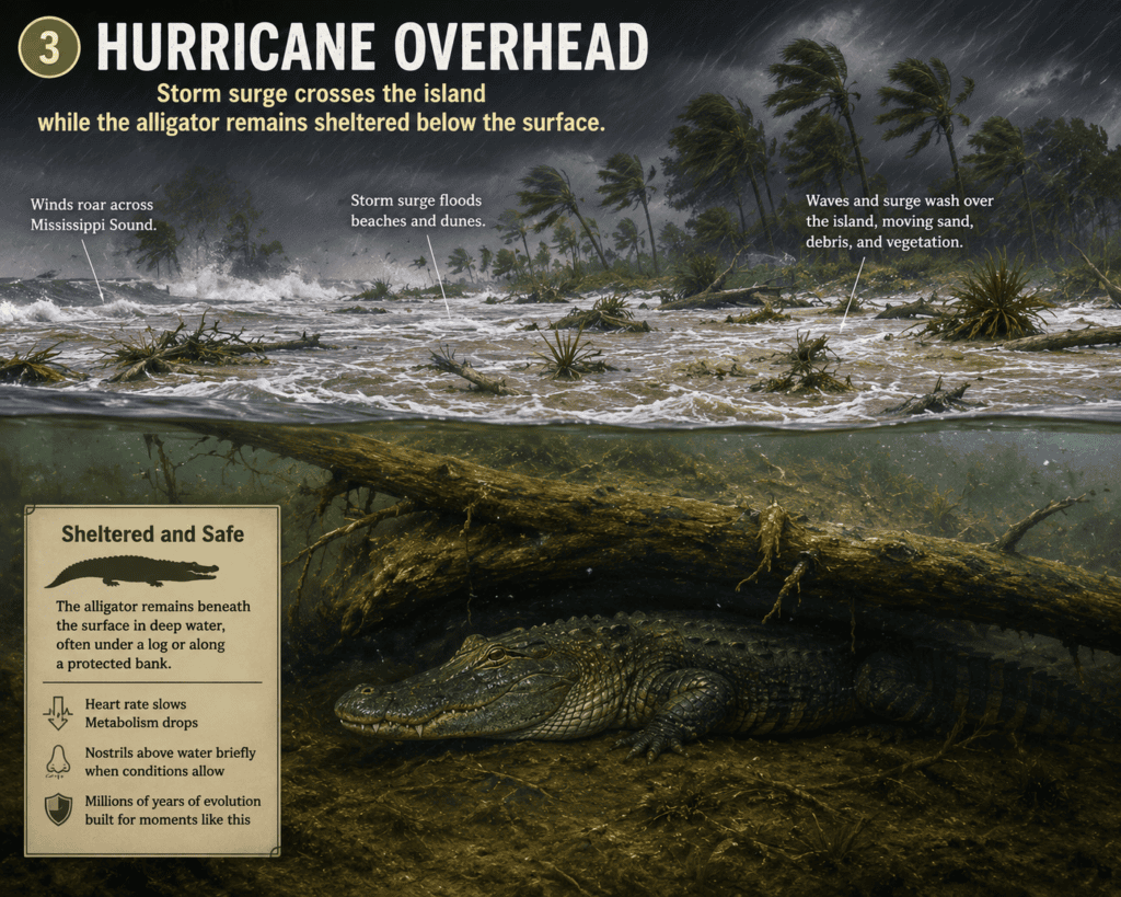
Hurricanes Can Move the Alligators
Although most alligators probably remain on Horn Island during a storm, hurricanes can move them against their will.
Storm surge may:
- Flood freshwater ponds with saltwater.
- Wash young alligators into new locations.
- Connect isolated wetlands.
- Create temporary waterways.
- Carry animals considerable distances.
Following major hurricanes, alligators are sometimes found in unusual places simply because floodwaters transported them there.
Freshwater Becomes the Priority
After a hurricane passes, Horn Island’s interior ponds may temporarily become much saltier because of storm surge washing across the island.
American alligators can tolerate brackish or saltwater for short periods, but they are fundamentally freshwater reptiles.
As rainfall gradually restores the island’s freshwater ponds, most alligators simply remain where they are.
If freshwater habitat remains unsuitable for an extended period, some animals may eventually leave the island in search of better conditions along the mainland’s rivers, marshes, and bayous.
Nature Has Been Testing Them for Millions of Years
Horn Island has endured countless hurricanes long before people began recording weather.
The island itself changes dramatically after major storms:
- Beaches migrate.
- Sand dunes shift.
- Trees fall.
- New ponds form.
- Existing ponds disappear.
- Shorelines move hundreds of feet.
Yet alligators continue returning to—and surviving on—the island.
Their ability to adapt to these changing conditions is one reason the American alligator has remained one of North America’s most successful predators for millions of years.
Author’s Perspective
Standing on Horn Island after a hurricane, it’s easy to think the storm changed everything.
The dunes may have shifted. Trees may be down. Driftwood may cover the beach.
But somewhere in one of the island’s quiet freshwater ponds, an alligator is probably doing what generations before it have done after every Gulf Coast hurricane—waiting patiently for the sun to return.
Like Horn Island itself, the alligator is remarkably resilient.
Never Approach an Alligator—Especially During Nesting Season
One of the most important safety rules on Horn Island is simple:
Never approach an alligator.
Although American alligators usually avoid people, they are powerful wild predators and should always be observed from a safe distance. This is especially true if you encounter a female guarding a nest or young hatchlings.
For most of the year, an alligator will often slip quietly into the water or move away when it notices people. During the nesting season, however, a female’s behavior can change dramatically.
She is protecting the next generation.
A Mother Alligator Is Extremely Protective
Female American alligators build large mound-shaped nests from vegetation, mud, leaves, and sticks near freshwater wetlands.
A typical nest contains:
- 30 to 50 eggs in a single clutch.
- Large females may lay more than 60 eggs under ideal conditions.
- Smaller females generally produce fewer eggs.
The eggs incubate inside the warm nest for approximately 60 to 65 days, with the heat generated by decaying vegetation helping to maintain the proper temperature.
Unlike many reptiles, female alligators remain nearby throughout much of the incubation period.
If a person unknowingly approaches too closely, she may view that individual as a threat to her nest.
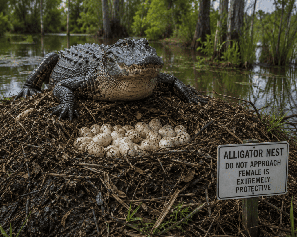
Nesting Season
Across the Gulf Coast, female American alligators typically:
- Build nests during late spring.
- Lay eggs during June and July.
- Guard the nest throughout the summer.
- Assist hatchlings when they emerge in late August or September.
If suitable nesting habitat exists, visitors should be especially cautious around freshwater ponds and marshes during this period.
Why Mother Alligators Become Aggressive
Most alligator encounters occur because people get too close.
A nesting female has one objective:
Protect her eggs and hatchlings.
She may:
- Hold her ground instead of retreating.
- Hiss loudly.
- Raise her head.
- Rush toward an intruder.
- Charge surprisingly quickly over short distances.
This defensive behavior is natural and should never be interpreted as the animal “attacking” without reason.
The easiest way to avoid a dangerous encounter is simply to keep your distance.
Few Hatchlings Survive
Although a female may lay dozens of eggs, only a small percentage of young alligators survive to adulthood.
Predators include:
- Raccoons
- Feral hogs
- Wading birds
- Large fish
- Otters
- Snakes
- Larger alligators
Flooding and hurricanes can also destroy nests before the eggs hatch.
By the time the surviving hatchlings reach adulthood, only a handful from the original clutch may remain.
Nature’s survival strategy is simple: produce many offspring because relatively few will survive.
If You See Baby Alligators…
One of the biggest mistakes visitors can make is assuming that a small alligator is harmless.
If you see hatchlings or juvenile alligators:
Assume the mother is nearby—even if you cannot see her.
Immediately:
- Back away slowly.
- Do not stop for photographs.
- Never attempt to touch a hatchling.
- Keep children and pets well away from the area.
- Leave quietly without disturbing the nest.
Mother alligators often remain hidden in nearby water or vegetation while watching over their young.
Safe Viewing Distance
Whether an alligator is eight inches long or twelve feet long, the safest approach is always the same:
- Observe from a distance.
- Never feed an alligator.
- Never block its path to the water.
- Never corner it.
- Never assume it is tame.
- If it changes its behavior because of your presence, you are already too close.
Horn Island offers one of the Gulf Coast’s best opportunities to observe wildlife in its natural environment. Respecting that wildlife—and giving it plenty of space—helps keep both visitors and alligators safe.
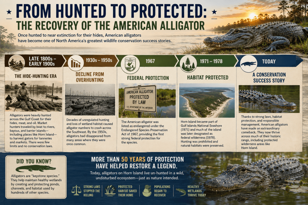
Were Alligators Ever Hunted on Horn Island?
Yes—almost certainly during the era of commercial hide hunting that affected alligator populations across the Gulf Coast.
Long before modern wildlife conservation laws, American alligators were heavily hunted for their valuable hides, meat, and oil. Throughout the late nineteenth and early twentieth centuries, market hunters traveled the rivers, marshes, bayous, and barrier islands of Mississippi in search of large alligators.
Although detailed harvest records specific to Horn Island are limited, the island’s freshwater ponds and wetlands would have offered suitable habitat for alligators and likely attracted hunters just as similar coastal habitats did elsewhere along the Gulf Coast.
The Commercial Hide-Hunting Era
From the late 1800s through the early 1900s, alligator hides became an important commercial commodity.
Hunters supplied tanneries that produced:
- Leather boots
- Shoes
- Handbags
- Belts
- Luggage
- Saddles
- Other specialty leather goods
Large alligators were especially valuable because they produced larger, higher-quality hides.
Like many wildlife species during this period, alligators were harvested with little regulation, and populations declined throughout much of their range.
World War II Changed the Island
During World War II, public access to Horn Island changed dramatically.
From 1943 to 1945, the U.S. Army established a Chemical Warfare Service research station on the island. Public access was restricted while military personnel occupied the facility.
Whether for recreation or commercial purposes, hunting activity on Horn Island effectively came to an end during this period.
Protection and Recovery
By the middle of the twentieth century, American alligator populations had declined severely across the southeastern United States because of decades of overharvesting and habitat loss.
Conservation efforts followed:
- States began adopting stronger hunting regulations.
- The American alligator received federal protection in 1967 under the Endangered Species Preservation Act.
- Later protections under the Endangered Species Act of 1973 further accelerated recovery.
- Careful wildlife management eventually allowed populations to rebound across much of the species’ range.
Today, the American alligator is considered one of North America’s greatest wildlife conservation success stories.
Horn Island Becomes Protected Wilderness
Horn Island entered a new chapter when it became part of Gulf Islands National Seashore in 1971. Much of the island was later designated as federally protected wilderness.
Today, the National Park Service manages Horn Island primarily to preserve its natural ecosystems.
As a result:
- Alligator hunting is prohibited on the island.
- Wildlife may not be harassed or disturbed.
- The island’s freshwater ponds remain important habitat for native species.
- Visitors can observe alligators behaving much as they have for centuries in a largely undisturbed wilderness setting.
More than fifty years of federal protection have helped preserve one of the Mississippi Gulf Coast’s most remarkable barrier-island ecosystems.
A Remarkable Conservation Success
The alligators visitors see on Horn Island today are part of a remarkable recovery story.
Once threatened by widespread commercial hunting, they now occupy protected wetlands where they once again play their natural role as apex predators.
Their presence serves as a reminder that effective conservation can restore wildlife populations while preserving the wild character of places like Horn Island for future generations.
Did Wild Hogs Ever Live on Horn Island?
Surprisingly, yes.
Although visitors are unlikely to encounter wild hogs on Horn Island today, feral pigs once played a fascinating role in the island’s history.
For many years, free-ranging hogs shared the island with cattle, helping tell the story of a time when Horn Island was not a protected wilderness but a working barrier island used by coastal families.
Early Settlers Released Hogs
During the nineteenth and early twentieth centuries, local families who owned or managed portions of Horn Island allowed livestock to roam freely.
In addition to cattle, they released hogs that foraged naturally throughout the island.
The animals fed on:
- Palmetto roots and tubers.
- Acorns and pine seeds.
- Marsh vegetation.
- Crabs and other small animals.
- Fallen fruit and seasonal vegetation.
Because Horn Island had freshwater ponds and abundant natural food, livestock could survive for extended periods with relatively little human attention.
Walter Anderson Encountered Them
When artist Walter Inglis Anderson explored Horn Island during the 1940s through the 1960s, he occasionally recorded encounters with free-ranging hogs in his journals.
He observed their tracks, movements and rooting behavior as part of his detailed study of the island’s wildlife.
According to accounts of his time on Horn Island, Anderson sometimes followed hog trails because they often led to hidden freshwater ponds or wet areas that other wildlife also used.
To Anderson, even the island’s hogs became another subject for careful observation and artistic inspiration.
Why Feral Hogs Are a Problem
Although fascinating historically, feral hogs are considered one of the most destructive invasive mammals in North America.
They can cause extensive damage by:
- Uprooting fragile dune vegetation.
- Destroying sea oats that stabilize sand dunes.
- Damaging marsh habitats.
- Eating eggs from ground-nesting birds.
- Disturbing sea turtle nests.
- Competing with native wildlife.
- Accelerating erosion by rooting through sandy soils.
Even a small population can dramatically alter sensitive coastal ecosystems.
What About Today?
Today, visitors are unlikely to encounter wild hogs on Horn Island.
Since Horn Island became part of Gulf Islands National Seashore and later received Federal Wilderness protection, preserving native ecosystems has become one of the National Park Service’s highest priorities.
The park manages invasive species to help protect:
- Native plants.
- Shorebirds.
- Sea turtles.
- Freshwater wetlands.
- Maritime forests.
- Other sensitive wildlife habitats.
While an occasional hog could theoretically reach the island following major flooding or hurricane events, there is no widely documented evidence of a large, established resident population today.
From Working Island to Wilderness
The disappearance of free-ranging livestock illustrates how dramatically Horn Island has changed over the past century.
Once used for grazing cattle and hogs, the island has gradually returned to something much closer to its natural condition.
Today, instead of finding livestock roaming the dunes, visitors are far more likely to encounter:
- White-tailed deer.
- Raccoons.
- Ghost crabs.
- Shorebirds.
- Ospreys.
- Dolphins offshore.
- And, if they venture near the island’s freshwater ponds, perhaps even an American alligator.
The transition from working island to protected wilderness is one of Horn Island’s greatest conservation success stories.
Are There Deer on Horn Island?
Many first-time visitors are surprised to learn that Horn Island is not known for having a resident population of white-tailed deer.
While white-tailed deer are common throughout the Mississippi Gulf Coast and can be found on the mainland and some nearby islands, Horn Island’s location and ecology make it an unlikely place to support an established herd.
Why Aren’t Deer Common on Horn Island?
Several natural factors work against a permanent deer population.
Distance from the Mainland
Horn Island lies approximately 8 to 10 miles offshore in Mississippi Sound.
White-tailed deer are excellent swimmers and regularly cross rivers, bayous, and narrow channels. However, swimming many miles across open saltwater with tides, currents, wind, and waves is far different from crossing a small creek or marsh.
While it is theoretically possible for an individual deer to reach the island under unusual circumstances, such events would be extremely rare.
Limited Habitat
Although Horn Island contains maritime forest, dunes, and freshwater ponds, it lacks many of the features that support a healthy deer population year-round.
Compared with mainland forests, the island has:
- Limited freshwater resources.
- Less diverse browse and forage.
- Smaller areas of protected woodland.
- Frequent hurricane disturbance.
- A continually changing landscape shaped by wind and storm surge.
These conditions make it difficult for a breeding population of large mammals to become established.
What Mammals Are You More Likely to See?
Instead of deer, Horn Island’s mammal community is made up primarily of smaller, highly adaptable species.
Visitors may encounter:
- Raccoons searching beaches and marsh edges for crabs, shellfish, and other food.
- Marsh rabbits moving through dense vegetation.
- Small rodents that inhabit the island’s forests and dunes.
- Various species of bats after sunset.
Historically, free-ranging cattle and feral hogs also lived on the island before it became protected wilderness.
Don’t Confuse Horn Island with Deer Island
One reason this question comes up so often is the existence of Deer Island, located just offshore from Biloxi.
Because Deer Island is much closer to the mainland, it has long been associated with white-tailed deer and other mainland wildlife.
Horn Island is very different. Its greater distance from shore and more isolated barrier-island environment support a unique community of coastal plants and animals rather than large land mammals.
Horn Island’s Real Wildlife Stars
Although visitors are unlikely to see deer, Horn Island offers outstanding opportunities to observe wildlife specially adapted to barrier-island life.
Keep an eye out for:
- American alligators around freshwater ponds.
- Ospreys diving for fish.
- Brown pelicans gliding along the shoreline.
- Ghost crabs racing across the beach.
- Dolphins feeding just offshore.
- Sea turtles during nesting season.
- Shorebirds migrating along the Gulf Coast.
These species—not white-tailed deer—are the true icons of Horn Island’s remarkable wilderness.
Horn Island Through the Seasons: When Is the Best Time to Visit?
One of the things that makes Horn Island so special is that it offers a different experience throughout the year. Unlike many beach destinations that are crowded every weekend, Horn Island remains relatively uncrowded because it requires a boat ride to reach. While thousands of tourists visit the Mississippi Gulf Coast every year, only a small percentage ever set foot on Horn Island.
Whether you’re looking for a lively holiday gathering, peaceful wilderness, excellent fishing, or comfortable weather for camping, choosing the right season can make your trip even more enjoyable.
🌸 Spring (March through May)
Spring is one of the most pleasant times to visit Horn Island.
Temperatures are comfortable, humidity remains relatively low, and wildlife becomes increasingly active. Migratory birds pass through the barrier islands, making spring an excellent season for birdwatching and photography. The interior freshwater ponds are full from winter rains, and many native plants begin blooming across the dunes and maritime forest.
Spring is also a wonderful time for kayaking, hiking, shell collecting, and exploring the island before the heat of summer arrives.
Spring Highlights
- Comfortable temperatures
- Active wildlife
- Excellent birdwatching
- Beautiful photography opportunities
- Pleasant camping weather
- Fewer insects than midsummer
☀️ Summer (June through August)
Summer is by far Horn Island’s busiest season.
Warm Gulf waters attract boaters from across the Mississippi Gulf Coast, and on weekends you’ll often see dozens of boats anchored near the island’s western beaches.
The biggest celebration of the year occurs during the Fourth of July holiday, when hundreds of visitors gather offshore and on the beaches to spend the day swimming, grilling, socializing, and enjoying one of Mississippi’s most unique boating traditions. Despite the holiday crowds at the west end, much of the island remains remarkably quiet and undeveloped.
Afternoon temperatures frequently reach the 90s, and humidity can be intense. Afternoon thunderstorms are common, making it essential to monitor marine weather before heading across Mississippi Sound.
Summer Highlights
- Warm Gulf water for swimming
- Peak boating season
- Fourth of July celebrations
- Excellent shelling after storms
- Great family beach trips
🍂 Fall (September through Early November)
Many experienced boaters consider fall the best overall time to visit Horn Island.
As summer crowds begin to fade, temperatures become more comfortable while Gulf water remains warm enough for swimming well into the season. Fishing is often outstanding, and camping becomes much more enjoyable.
Although the Atlantic hurricane season officially continues through November 30, the period after the first week of November generally marks the transition into a much quieter weather pattern along the Mississippi Gulf Coast. This often provides some of the year’s most enjoyable boating conditions.
If you’re looking for peaceful beaches without the summer crowds, fall is hard to beat.
Fall Highlights
- Comfortable temperatures
- Warm water
- Excellent fishing
- Outstanding camping
- Smaller crowds
- Beautiful sunsets
❄️ Winter (Late November through February)
Winter offers an entirely different Horn Island experience.
The beaches are often nearly empty, making this the perfect season for photographers, nature lovers, and anyone seeking solitude. Cooler temperatures make long walks along the shoreline especially enjoyable, and migrating birds provide excellent wildlife viewing opportunities.
Cold fronts can occasionally bring rough water across Mississippi Sound, so boaters should carefully monitor marine forecasts before making the crossing.
For many visitors, winter is the season when Horn Island truly feels like an untouched wilderness.
Winter Highlights
- Peaceful beaches
- Excellent photography
- Bird migration
- Comfortable hiking weather
- Incredible solitude
Why Horn Island Never Feels Crowded
One of Horn Island’s greatest attractions is that it remains remarkably uncrowded compared to many Gulf Coast destinations.
Unlike nearby Ship Island, which is served by a scheduled passenger ferry, Horn Island has no public ferry service.Every visitor must arrive by private boat, kayak, water taxi, or licensed charter captain. That extra effort naturally limits the number of people who visit, preserving the island’s wilderness character.
Even during the busiest summer weekends, it’s often possible to walk a short distance from the popular beach areas and find long stretches of shoreline almost entirely to yourself.
Charter Boats and Water Taxi Services
If you don’t own a boat, don’t worry—there are several charter captains and water taxi operators that regularly transport visitors to Horn Island.
Many offer:
- Half-day and full-day island excursions
- Private family beach trips
- Camping drop-off and pick-up service
- Photography outings
- Shelling excursions
- Eco-tours
- Fishing and island combination trips
Some vessels accommodate only six passengers under Coast Guard “6-pack” regulations, while larger passenger boats can transport bigger groups, making Horn Island accessible for families, reunions, and organized outings.
Before booking, ask about:
- Maximum passenger capacity
- Beach landing procedures (you’ll usually wade ashore)
- Coolers and beach gear
- Shade equipment
- Camping transportation
- Weather cancellation policies
Planning Tips Before You Go
Because Horn Island is a federally designated wilderness area, visitors should come prepared.
✔ Bring plenty of drinking water.
✔ Pack sunscreen, hats, and shade.
✔ Carry all food you’ll need for the day.
✔ Bring insect repellent during warm months.
✔ Wear footwear suitable for shallow-water landings.
✔ Check the marine weather forecast before departing.
✔ Pack out everything you bring—there are no trash cans, restrooms, docks, or concession facilities.
A little preparation goes a long way. Those who plan ahead are rewarded with one of the Gulf Coast’s most pristine beaches, abundant wildlife, and a true wilderness experience that few visitors to Mississippi ever discover.
Continue Your Horn Island Adventure
Horn Island is far more than a beautiful stretch of sand in the Gulf of Mexico. It is a place where history, wildlife, art, and conservation come together to create one of the most remarkable barrier islands in the United States.
Whether you’re planning your first visit or you’ve explored the island many times, every trip reveals something new—from nesting shorebirds and freshwater ponds to the legacy of Walter Anderson and the fascinating history hidden among the dunes.
If you enjoyed this guide, continue exploring the Mississippi Gulf Coast with RetireCoast. We have created hundreds of in-depth articles covering the region’s barrier islands, beaches, coastal communities, outdoor adventures, history, retirement, and hidden gems.
Continue Exploring
- Discover more Mississippi Gulf Coast travel guides
- Explore our Barrier Islands collection
- Learn about Ship Island, Cat Island, Deer Island, and Petit Bois Island
- Read more stories about Walter Anderson and Gulf Coast history
- Find boating, fishing, kayaking, camping, and beach guides
- Plan your next Mississippi Gulf Coast adventure
Every article is written to help you experience the Gulf Coast like a local—with practical advice, fascinating history, and beautiful photography and illustrations that bring these special places to life.
If this guide helped you, please share it with friends and family who love the outdoors, history, wildlife, or the Mississippi Gulf Coast. Together we can inspire more people to appreciate—and help protect—the incredible natural beauty of Horn Island for generations to come.
Explore More at RetireCoast
Visit our Mississippi Gulf Coast Living Hub for hundreds of free travel guides, local history articles, retirement resources, and destination ideas designed to help you experience the best of Coastal Mississippi.
Explore Mississippi’s Barrier Islands
Horn Island is part of a remarkable chain of barrier islands stretching across the Mississippi Gulf Coast. Although the islands share white-sand beaches, productive coastal waters, and beautiful Gulf views, each offers a distinctly different experience.
Deer Island
Deer Island sits just offshore from Biloxi and is the easiest of Mississippi’s undeveloped islands to see from the mainland. Local boaters visit its beaches for swimming, fishing, kayaking, picnicking, and primitive camping.
Because it is so close to Biloxi, Deer Island can provide a convenient introduction to barrier-island recreation without requiring a long trip across the Mississippi Sound. Much of the island is managed as part of the Mississippi Coastal Preserves system.
Learn more in our complete guide:
Deer Island: A Free Beach Adventure Near Biloxi
Ship Island
Ship Island offers the most structured visitor experience. Seasonal passenger ferry service operates from Gulfport, allowing people without boats to enjoy the island’s beaches, swimming areas, and historic Fort Massachusetts. This combination of ferry access, recreation, and history makes Ship Island a popular choice for families and first-time barrier-island visitors.
Cat Island
Cat Island lies west of Ship Island and attracts boaters, anglers, campers, and visitors seeking quieter beaches. Unlike Horn Island, Cat Island is not entirely public land. Portions are privately owned, and a small number of private houses can be seen on the island. Visitors should verify where public access is permitted and respect private property when landing or exploring.
Fishing Around the Barrier Islands
Fishing around Horn Island, Ship Island, Deer Island, and Cat Island is considered some of the best along the Mississippi Gulf Coast. Anglers fish the passes, grass beds, beaches, channels, artificial reefs, and waters on both sides of the islands for a variety of inshore and nearshore species.
Mississippi also maintains extensive artificial-reef areas north and south of the barrier islands, adding habitat and fishing opportunities throughout the region.
Conditions can change quickly around the islands, so anglers and recreational boaters should check marine weather, tides, fishing regulations, and current navigational information before leaving shore.
Which Barrier Island Is Right for You?
Some visitors want scheduled ferry transportation and a family beach day. Others prefer fishing, camping, wildlife photography, or the solitude of an undeveloped wilderness island.
Use the free Which Mississippi Barrier Island Is Right for You? tool below to compare Horn Island, Ship Island, Deer Island, and Cat Island. Answer 10 quick questions about transportation, facilities, camping, fishing, history, wildlife, and your preferred travel style to receive a personalized island recommendation.
Free Tool: Which Barrier Island is Right For you
Not Sure Which Mississippi Barrier Island Is Right for You?
Each of Mississippi's barrier islands offers a completely different experience. Some are perfect for day trips and history lovers, while others are remote wilderness destinations best suited for experienced boaters and campers. If you're wondering where to begin, let our interactive quiz help narrow the choices.
🌊 RetireCoast Coastal Curiosity
Don’t forget to visit the Isle of Caprice…
Just kidding!
If you head west from Horn Island looking for the famous Isle of Caprice, you’ll need scuba gear instead of a beach chair. Once one of the most glamorous destinations on the Mississippi Gulf Coast, the island featured a casino, hotel, dance pavilion, and other buildings that attracted visitors from across the South during the early 1900s.
Hurricanes and relentless coastal erosion eventually claimed the island. Today, the remains of the Isle of Caprice rest beneath approximately four feet of Gulf water just west of Horn Island, making it one of the Gulf Coast’s most fascinating “lost islands.”
We’ll tell the remarkable story of the rise and disappearance of the Isle of Caprice in another RetireCoast article—it’s a piece of Mississippi history you won’t want to miss.
Authoritative References
For readers who would like to learn more about Horn Island, its wildlife, geology, history, and conservation, the following organizations provide reliable, research-based information.
- National Park Service – Gulf Islands National Seashore
Official information about Horn Island, visitor planning, regulations, history, wilderness protection, and recreational opportunities.
Gulf Islands National Seashore (National Park Service) - U.S. Geological Survey (USGS) – Geophysical Data from Offshore of Horn Island
Scientific research on the geology, seafloor, and coastal processes surrounding Horn Island and the Mississippi barrier islands. (USGS Publications)
USGS Open-File Report 2010-1178 - U.S. Geological Survey (USGS) – Nearshore Coastal Bathymetry of Horn Island
Detailed scientific mapping and coastal bathymetry data for Horn Island and surrounding waters. (USGS Publications)
USGS Data Series 1081 - Walter Anderson Museum of Art
Learn about Walter Anderson’s life, his connection to Horn Island, and the artwork inspired by Mississippi’s barrier islands. (Walter Anderson MoA)
Walter Anderson Museum of Art - National Park Service – Walter Anderson and Horn Island
The National Park Service’s history of Walter Anderson’s relationship with Horn Island and its importance as a source of artistic inspiration. (National Park Service)
Walter Anderson – National Park Service - U.S. Fish & Wildlife Service – American Alligator
Official information about the biology, habitat, conservation, and recovery of the American alligator throughout the southeastern United States.
U.S. Fish & Wildlife Service – American Alligator - Mississippi Department of Wildlife, Fisheries, and Parks
Information on Mississippi wildlife, outdoor recreation, conservation programs, boating safety, and hunting and fishing regulations.
Mississippi Department of Wildlife, Fisheries, and Parks - National Oceanic and Atmospheric Administration (NOAA)
Marine weather forecasts, coastal conditions, tides, nautical charts, and Gulf of Mexico environmental information useful for anyone planning a trip to Horn Island.
NOAA National Weather Service Marine Forecasts
These references provide authoritative information from federal agencies, scientific organizations, and recognized cultural institutions that support the historical, ecological, geological, and recreational information presented throughout this guide.
Quiz
FAQ
How do you get to Horn Island?
Can you camp on Horn Island?
Are there alligators on Horn Island?
Is it safe to swim on Horn Island?
Can you drink the water on Horn Island?
Are there snakes on Horn Island?
Can I bring my dog?
Why are there freshwater ponds on a barrier island?
Did Walter Anderson really row to Horn Island?
Can you hunt or disturb wildlife on Horn Island?
Can you find historical ruins on Horn Island?
What wildlife might I see?
- American alligators
- Ghost crabs
- Brown pelicans
- Ospreys
- Herons and egrets
- Sea turtles (nesting season)
- Dolphins offshore
- Numerous migratory shorebirds
Are there sharks around Horn Island?
What should I do if I encounter an alligator?
When is the best time to visit Horn Island?
Horn Island is only one part of the Mississippi Gulf Coast story. RetireCoast also provides in-depth destination guides, interactive tools, financial resources, estate-planning education, and business planning support designed to help readers make informed decisions.
Continue exploring the coast through our comprehensive Gulf Coast guide, or discover the growing library of premium RetireCoast memberships, tools, courses, and planning resources.
Discover coastal communities, beaches, boating, fishing, food, history, tourism, retirement, real estate, and the unique lifestyle found along the Mississippi Gulf Coast.
- Destination and travel guides
- Beaches, harbors, fishing piers, and boating resources
- Local food, history, attractions, and communities
- Retirement and relocation information
RetireCoast memberships provide access to specialized planning tools, guided resources, educational courses, and continuously expanding support for families, retirees, entrepreneurs, and property owners.
- Estate Planning Membership tools and Academy courses
- Business Builder Membership resources
- Millennial Financial Lab tools
- All-Access Membership covering every membership
Discover more from RetireCoast.com
Subscribe to get the latest posts sent to your email.